
The Reykjanes eruption is a volcanic event on Iceland’s southwestern peninsula that began in December 2023. Located on the Mid-Atlantic Ridge, the peninsula sits where two tectonic plates slowly pull apart. After 800 years of dormancy, magma found a path to the surface. The eruption reshaped a coastline and opened a new chapter in Iceland’s geologic story.
Reykjanes Eruption: 800 Years of Silence Broken
The last time the Reykjanes Peninsula erupted, the Viking Age was not yet over. For 800 years, the land sat still. Geologically speaking, that is not a long time. But for the people who built roads, homes, and a fishing town called Grindavík on that ground, it felt like permanence.
In March 2021, the silence ended. A fissure opened on Fagradalsfjall, a shield volcano that had not erupted since the 12th century. Lava poured out slowly at first, then more steadily. Scientists and tourists hiked up to watch. It was dramatic, but it was manageable.
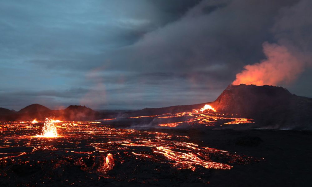
What happened in late 2023 was different in scale and proximity. The eruptions moved closer to Grindavík. In December, a 3-kilometer fissure opened overnight. The town was evacuated. The Blue Lagoon geothermal spa closed. The ground had cracked open 800 meters from someone’s front door.
Understanding why this happened requires looking at what Reykjanes actually is: a surface expression of one of the most active plate boundaries on Earth.
Reykjanes Eruption on the Mid-Atlantic Ridge
Iceland exists because of the Mid-Atlantic Ridge, the underwater mountain range that runs from the Arctic to the South Atlantic. Along this ridge, the Eurasian and North American tectonic plates move apart at roughly 2.5 centimeters per year. That is about the speed your fingernails grow.
Where most of this ridge is submerged, Iceland is the exception. A volcanic hotspot sits beneath the island, producing so much magma that it has built land above sea level. Reykjanes is where this hotspot system meets the surface most directly.
The peninsula is essentially a piece of the ridge made walkable. At Þingvellir, 50 kilometers to the east, you can stand in the rift valley and see both continental plates rising on either side. At Silfra, you can dive between them. At Reykjanes, you can watch the gap fill with lav
Why Grindavík and Why Now: The Seismic Sequence
Before each eruption, Iceland’s seismometers registered thousands of small earthquakes. This is magma moving through rock. As it rises, it fractures the crust above it. Scientists at the Icelandic Meteorological Office tracked these swarms in real time.
The sequence that led to the December 2023 eruption was the most intense in the area since measurements began. More than 1,400 earthquakes were recorded in a single 24-hour period in November. The largest reached magnitude 4.8.
What made this cycle alarming was the location. The magma dyke, a sheet of molten rock forcing itself into cracks, was oriented directly beneath and toward Grindavík. Residents had days, sometimes hours, to evacuate. Some returned briefly to collect belongings. Others did not get the chance.
By January 2024, lava had reached the edge of the town. Several homes were destroyed. The geothermal infrastructure serving the region was damaged. An ancient fishing community found itself on the front line of a planetary process it had no power to stop.
Reykjanes Eruption: What the Lava Reveals
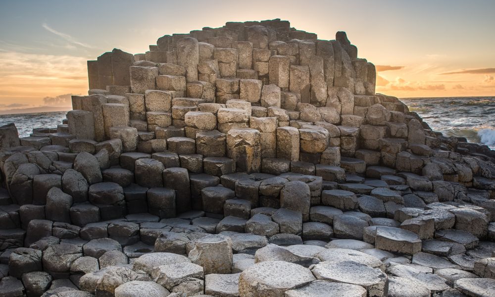
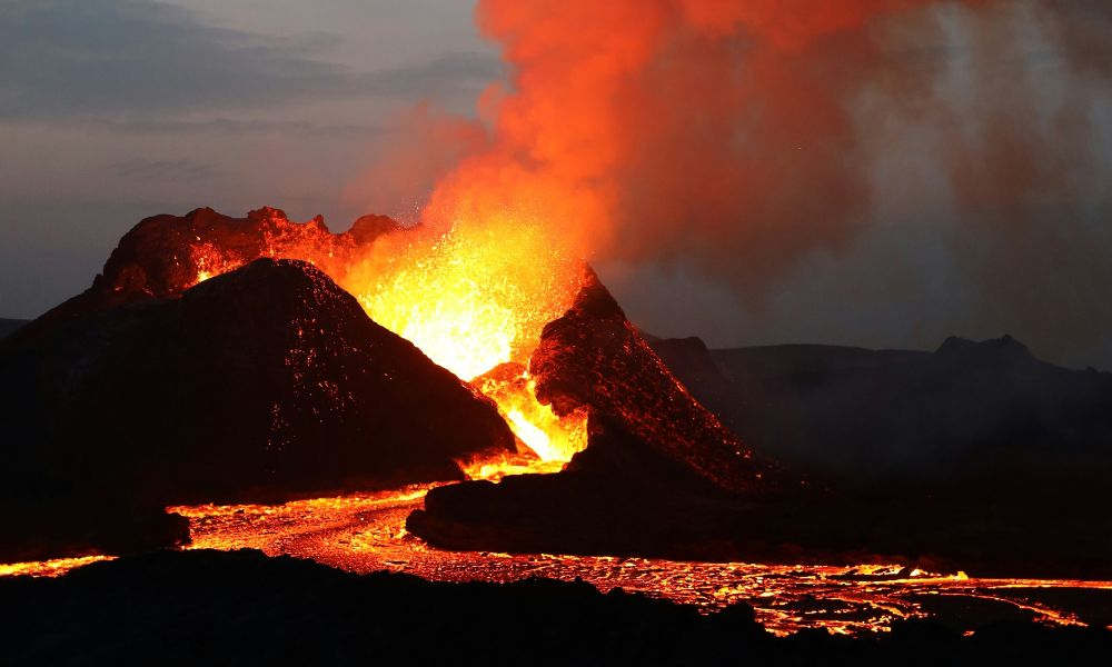
The lava erupting from Reykjanes is basalt. It is the most common rock type on Earth’s surface and the primary material of the ocean floor. Dark, dense, fine-grained. When it cools slowly, it forms hexagonal columns. When it cools fast, it hardens into a glassy black crust.
Basalt is the rock that tells you where you are in the planet’s history. It forms at diverging plate boundaries and at hotspots. Iceland has both. That is why the island is essentially a library of basalt, written in flows that stack on top of each other over millions of years.
The fresh Reykjanes lava is already being studied. It carries chemical signatures that help volcanologists understand the composition of the mantle below. The ratio of certain isotopes reveals how deep the magma came from, how long it spent in the crust, and whether it mixed with older material on the way up.
To walk on this lava, even months after it cooled, is to walk on a page that was just written. The rock beneath your feet did not exist a year ago.
Living With an Active Rift: Iceland’s Relationship With Its Ground
Iceland has been managing volcanic risk for over a thousand years. The Norse settlers who arrived in the 9th century knew the land was volatile. Snorri Sturluson, the medieval historian, documented eruptions in the 13th century. Laki erupted in 1783 and killed roughly 20% of Iceland’s population, not from lava, but from fluorine poisoning the grass, which poisoned the sheep, which starved the people.
Modern Iceland monitors its ground obsessively. The network of GPS sensors, seismometers, and gas detectors is among the densest in the world. Eruptions are rarely a complete surprise. The challenge is predicting where the lava will go once it starts.
The Reykjanes events have accelerated discussions about managed retreat from certain coastal and low-lying areas. Grindavík is being evaluated for permanent resettlement. No decision has been made. But for the first time, a town is seriously discussing the possibility that its location is no longer viable.
This is what it looks like when a geological process intersects with a human community. The Earth is not hostile. It is simply indifferent to property lines.
Frequently Asked Questions
Is the Reykjanes Eruption Still Happening?
Reykjanes entered an active eruptive phase in 2021 and has continued intermittently since. Eruptions have paused and restarted multiple times. The underlying volcanic system remains active, and scientists consider continued eruptions likely over the coming years.
Can I Visit Reykjanes During an Eruption?
Access depends on the current situation and safety exclusion zones set by Icelandic authorities. During some eruption phases, viewing areas were opened to the public. During others, roads were closed entirely. Always check the Icelandic Meteorological Office website before visiting.
What Is the Reykjanes Eruption 2024 Timeline?
The December 2023 fissure opened near Grindavík, leading to evacuation. Multiple eruptive episodes followed in January, February, and March 2024, with lava reaching the town perimeter. The Blue Lagoon closed and reopened several times. Each new eruption has started from a slightly different location along the same underground magma pathway.
What This Place Teaches
What This Place Teaches
Reykjanes shows that a tectonic plate boundary is not a theoretical line on a map. It is a living system that erupts, cracks,is is not metaphor. The ground is actively spreading. The eruptions are not random. They are the visible result of plates pulling apart, creating space that magma fills from below.
For Young Explorers
Find a satellite image of Reykjanes on Google Earth and compare it to an image from 2020. Can you spot the new lava fields? Count how many kilometers of coastline changed.
The Deep Time Angle
The Mid-Atlantic Ridge has been spreading for 65 million years. At 2.5 cm per year, Europe and North America are now 1,625 kilometers farther apart than when the last non-avian dinosaurs were alive.
Further Reading
Book: Eruption by Alexandra Witze and Jeff Kanipe. App: Veðurstofa Íslands (official Icelandic Met Office). Scientific reference: Sigmundsson et al., 2022, Magma accumulation in Reykjanes, Nature Geoscience.
About the author
Daniel is a science communicator and field traveler with many years of experience covering Earth science for general audiences. He has walked Reykjanes lava fields between eruptions and written on volcanic systems across the North Atlantic. His work at Geonatra bridges geology and conscious travel.
Pingback: Basalt, Obsidian, Lava Fields: How to Read the Rocks of Iceland - Geonatra
Pingback: Deep time in Iceland: when did this island actually form? - Geonatra
Pingback: Iceland Geysers Explained: The Science Behind Strokkur