Most people drive Iceland’s Ring Road and come back with photographs. A thousand kilometres of lava fields, glaciers and black beaches, compressed into a week. The landscapes stay with you, but the questions they raise often don’t get answered. Why does Iceland look like this? Why here, and not somewhere else? Why does the ground steam, the water explode, the ice sit on top of fire?
The Ring Road doesn’t just connect Iceland’s highlights. It connects the chapters of a geological story that is still being written. These seven stops are where that story is easiest to read.
How To Read Iceland From a Car Window
Iceland sits directly on the Mid-Atlantic Ridge, the boundary where the North American and Eurasian tectonic plates pull apart. This is not a metaphor or a distant abstraction. Drive the Ring Road and you cross that boundary. You follow lava flows that are younger than medieval cathedrals. You park next to glaciers sitting on active volcanoes. The geology here is not buried or ancient. It is happening.
What makes the Ring Road unusual as a geological itinerary is that each region of Iceland records a different kind of Earth process. Rifting, volcanism, glaciation, hydrothermal activity, erosion. One road, one island, almost the entire vocabulary of how the Earth reshapes its surface.
The 7 Stops
1. Reykjanes Peninsula
The drive south from Reykjavik crosses a landscape that looks post-apocalyptic: fractured lava, no trees, sulphurous vents close to the road. This is one of the only places on Earth where a mid-ocean ridge rises above sea level. The boundary between the North American and Eurasian plates runs directly through this peninsula, and it is not theoretical. You can walk along the rift valley at Reykjanesviti, where the ground has been pulled apart and the gap filled, repeatedly, with fresh basalt.
| The geological lesson: The boundary between two continents is not underwater here. You can stand on it. |
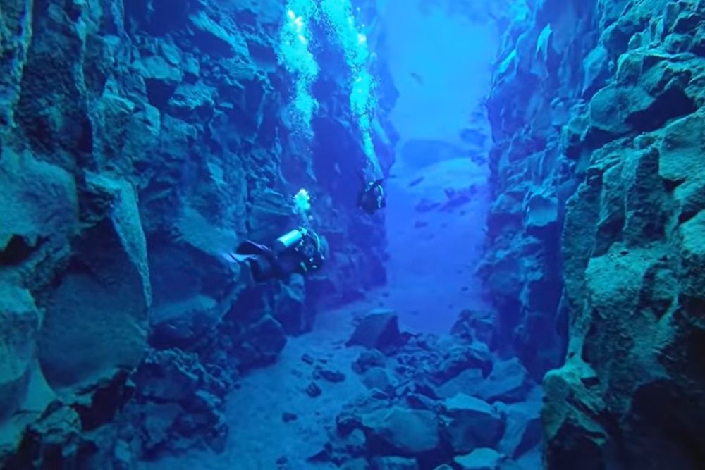
2. Þingvellir and the Silfra rift
Þingvellir is Iceland’s most visited historical site, the location of the world’s oldest parliament. But the geology is just as significant. The valley floor has dropped several metres as the two tectonic plates pull apart at roughly two centimetres per year. Silfra is the crack between them, filled with glacial water so clear that visibility reaches over 100 metres. Divers describe the experience as floating between continents. They are not wrong.
| The geological lesson: Two centimetres per year sounds modest. Over a million years, it moves 20 kilometres. Iceland is quietly being split in two. |
3. Geysir
The word ‘geyser’ comes from Geysir, which has been erupting intermittently for thousands of years. The mechanism is straightforward: groundwater percolates down through volcanic rock, is heated beyond boiling point under pressure, and eventually releases that pressure upward in a column of steam and water. Strokkur, the active geyser beside the original Geysir, erupts every five to ten minutes. Watching it, you understand that what looks like a performance is simply physics, running on geothermal heat that has no intention of stopping.
| The Geological Lesson: A geyser is a pressure valve. The Earth is always managing its own heat, whether we are watching or not. |
4. Vatnajökull
Vatnajökull is Europe’s largest glacier by volume, covering around 8% of Iceland’s surface. Beneath it sit several active volcanoes. When those volcanoes erupt under the ice, the meltwater has nowhere to go except outward, in floods that can carry more water than the Amazon. The relationship between fire and ice here is not a contrast, it is a system. One drives the other. We covered this dynamic in detail in our article on Vatnajökull: what happens when a glacier sits on top of a volcano.
| The Geological Lesson: The most dramatic geological events in Iceland happen not at the surface, but in the space between fire below and ice above. |
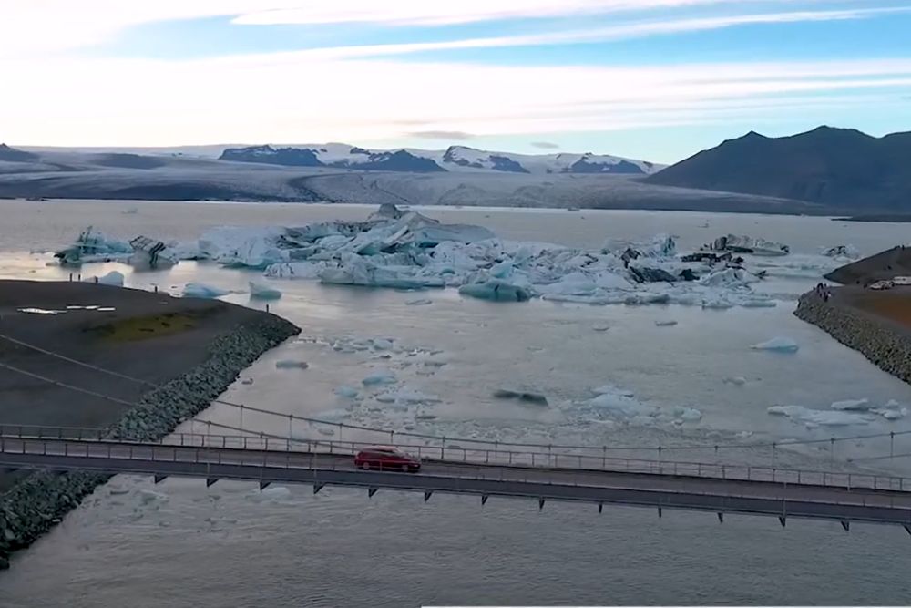
5. Jökulsárlón
A few kilometres from Vatnajökull’s southern edge, icebergs calve into a lagoon before drifting to the sea. Jökulsárlón did not exist a century ago. The lagoon formed as the glacier retreated, and it has grown steadily since. The blue and white icebergs floating in it are ice that fell as snow hundreds of years ago, compressed into glacial ice, and is now melting. The lagoon is a slow-motion record of climate written in ice and water.
| The Geological Lesson: Jökulsárlón is not a permanent feature of Iceland. It is a consequence, and it is still growing. |
6. Dettifoss
Dettifoss carries more water over its edge than any other waterfall in Europe. What makes it geologically interesting is not the scale but the material: the water falls over basalt columns, carved by repeated floods from glacial outbursts thousands of years ago. The canyon it has cut, Jökulsárgljúfur, is the result of water working on rock over millennia. Patient, persistent, and more powerful than anything built by human hands. The full story is in our article on Dettifoss: the waterfall that moves.
| The Geological Lesson: Water is soft. Basalt is hard. Given enough time, water wins, every time. |
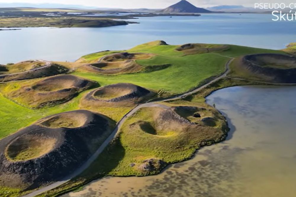
7. Mývatn
Lake Mývatn was born from a volcanic eruption roughly 2,300 years ago. The lava flow that created it dammed a river and formed the lake. What followed is one of geology’s quieter stories: an entire ecosystem assembling itself around geothermal heat. The lake is shallow, warm in places, and extraordinarily productive. Pseudo-craters dot its shores, formed not by volcanic vents but by steam explosions when lava flowed over wet ground. It looks volcanic. The mechanism is different.
| The Geological Lesson: A catastrophic eruption can create, not just destroy. Mývatn is what happens when geology gives life a foundation. |
What Connects These Seven Places
None of these stops is static. Þingvellir is still widening. Jökulsárlón is still growing. The geysers at Geysir erupt on their own schedule, indifferent to visitors. The glaciers are moving, the volcanoes are not dormant so much as patient. The Ring Road connects places that are all, in different ways, mid-process.
That is what makes Iceland unusual as a destination. Most geological landscapes show you results. Iceland shows you the work still in progress. The Ring Road is the best way to see the full range of that work in a single journey.
What This Place Teaches
What this place teaches: A single road can cross every major type of geological process active on Earth today. Iceland is not an exception to how the planet works. It is the most legible example of it.
For young explorers: Keep a field notebook for the drive. At each stop, draw one thing you see and write one sentence about what created it. By the end of the Ring Road, you will have a geological map made entirely from your own observations.
The deep time angle: Iceland is between 16 and 20 million years old. The Alps are around 35 million years old. Iceland is, by geological standards, a very young island, still being built in real time.
Further reading: The Icelandic Meteorological Office publishes up-to-date data on volcanic and seismic activity across Iceland at en.vedur.is.
Pingback: Iceland’s Geological Places: Guide to Most Significant Sites
Pingback: Iceland Volcanic Rift: The Seam That Built Earth