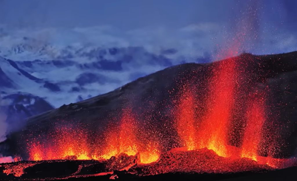
Night on the Reykjanes Peninsula. The sky is dark, but the horizon is not. A deep orange glow pulses beyond the ridge, steady and slow, like something breathing. The ground beneath your feet feels faintly warm through the soles of your boots, and every few minutes a low tremor moves through you. Not enough to knock you off balance. Just enough to remind you that the surface you are standing on is not as solid as it looks.
You are standing on Iceland. And tonight, the country is doing what it has always done.
Most people see this and think: fire. They think danger, spectacle, evacuation alerts. Those things are real. But underneath the spectacle is a story, one that stretches back millions of years and still is not finished. The glow on the horizon is not a malfunction. It is the planet doing its work, building new crust, reshaping coastlines, adding a few more square kilometres to an island that did not exist when the dinosaurs disappeared.
Iceland volcanoes explained simply: two enormous geological forces meet here, and the result is a landscape that has no real equivalent anywhere else on Earth. Where does this fire actually come from?
Iceland Volcanoes: Born at the Crossroads
Iceland sits on one of the most geologically active spots on Earth, and that is not an accident of location. Two separate forces meet here, and together they have produced an island unlike any other.
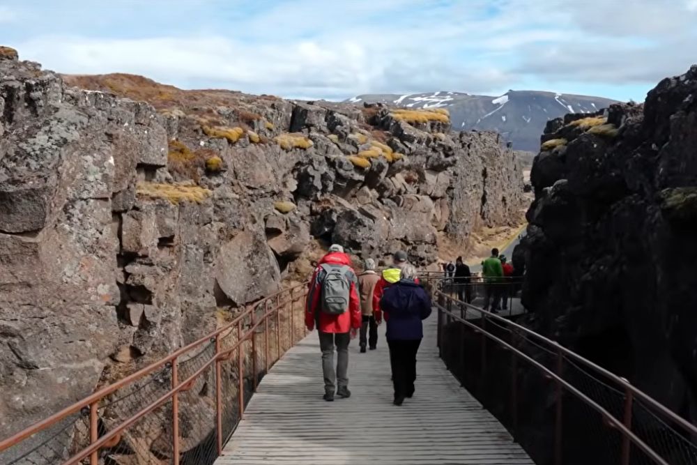
The first force is the Mid-Atlantic Ridge, a mountain range running along the floor of the Atlantic Ocean from north to south. It is one of the longest mountain ranges on the planet, mostly hidden beneath the sea. Two tectonic plates, the North American and the Eurasian, pull away from each other along its length. As they separate, molten rock from the mantle rises to fill the gap. Iceland sits directly on top of this ridge, which is why it is one of the few places on Earth where you can walk across a spreading plate boundary on dry land. Standing on two continents at Silfra shows you exactly what that boundary looks like.
The second force is a hotspot, a column of unusually hot mantle material that punches upward through the crust regardless of which plate happens to sit above it. Think of a blowtorch held steady beneath a slowly moving sheet of paper. The paper moves, the flame stays in place. The result is a chain of burn marks across the seafloor. Iceland is the most recent and most intense.
When these two forces align, the volcanic output is extraordinary. More eruptions per square kilometre than almost anywhere else on Earth. A landscape that is visibly, constantly being remade.
| The Science in Brief: Mid-Atlantic Ridge: the boundary where the North American and Eurasian plates pull apart at roughly 2.5 cm per year. Hotspot: a plume of unusually hot mantle rock that feeds volcanic activity independently of plate boundaries. Basalt: the dark, dense rock that forms when lava from the mantle cools rapidly at the surface. Magma chamber: a reservoir of molten rock beneath the surface that feeds eruptions when pressure builds. |
How to Read Iceland Volcanoes in Stone
Every rock you walk across in Iceland is a sentence in a very long book. The challenge is knowing how to read it. Our guide to Icelandic rocks covers each rock type in detail, but here is the short version.
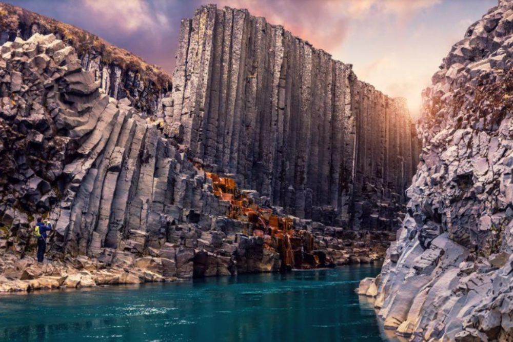
Basalt is the most common word. Dark grey, dense, often found in columns or as sprawling lava fields, it forms when lava from the mantle cools relatively quickly at the surface. Most of Iceland is built from it. The black sand beaches, the cathedral-like columns at Reynisfjara, the entire floor of the interior highlands.
Then there is obsidian. When lava cools so fast that molecules do not have time to arrange into crystals, the result is volcanic glass. Nearly shiny, sometimes jet black, sometimes with a faint green tint. If you find a piece, you are holding rock that solidified in minutes.
The lava fields themselves tell two different stories depending on their surface. Pahoehoe lava flows slowly and cools into smooth, rope-like coils, almost gentle to walk across. Aa lava moves faster, tumbles over itself, and cools into a jagged, broken crust that makes crossing the field a genuine physical challenge. The same eruption can produce both. Different speed, different story written in stone.
Reading these surfaces is how volcanologists reconstruct past eruptions without any written records. The texture of the rock is the archive.
The Reykjanes Awakening: What The Earth Is Telling Us
iceland volcanoes explained : For roughly 800 years, the Reykjanes Peninsula was quiet. The last significant eruption cycle in this area ended around the 13th century, and the landscape settled into something that looked almost stable. Towns were built. A geothermal power plant was constructed. An international airport grew up at Keflavík.
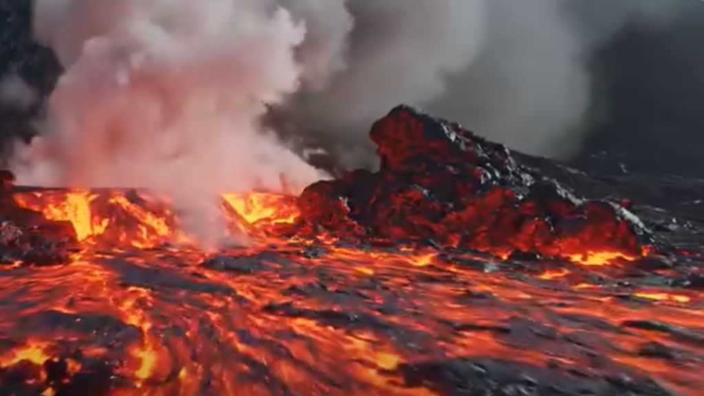
Then, in 2021, the earth broke open.
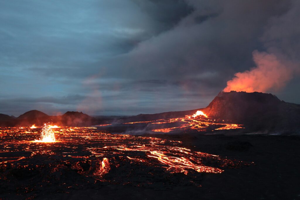
Since that first eruption at Fagradalsfjall, the peninsula has seen multiple fissure events, with the most dramatic episodes occurring near Grindavík in late 2023 and into 2024. These are not the cone-shaped eruptions most people picture. They are linear fissures, long cracks in the crust where lava pours out in curtains rather than from a single central vent. The shape of the eruption reflects the shape of the geology: a spreading boundary, not a single puncture. The full story of what happened at Reykjanes traces each eruption in sequence.
According to the Icelandic Meteorological Office, which monitors seismic and volcanic activity across the country, the Reykjanes system is now in a period of reactivation that could last for decades. This is not an anomaly. It is a return to a pattern that existed long before anyone built anything here.
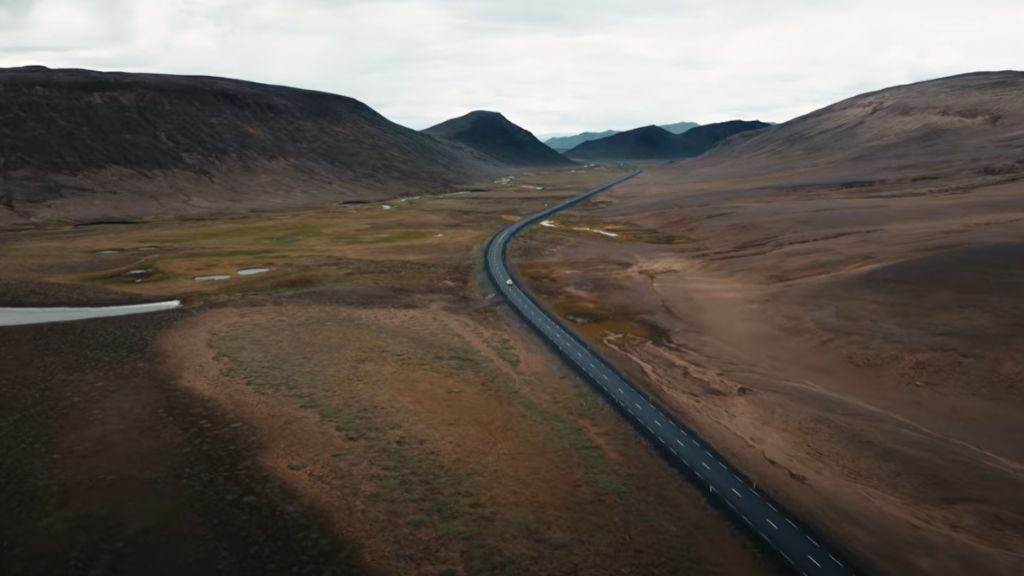
For anyone visiting the area around Keflavík, the Blue Lagoon, or the broader peninsula, this means the landscape is genuinely changing in real time. Lava fields that did not exist three years ago are already being colonised by moss. The island is growing.
Standing on the Youngest Island on Earth
Iceland is young by geological standards. The oldest rocks in the country date back roughly 16 to 20 million years, which makes it a child compared to most landmasses. The Scottish Highlands formed over 400 million years ago. The Canadian Shield is approaching three billion. Iceland is barely a toddler.
Here is a way to feel that. If you compressed the entire history of the Earth into a single 24-hour day, Iceland would not appear until roughly the last two minutes. Everything you see here, the mountains, the glaciers, the entire island, emerged in the final moments of a very long story.
And the story is not over. The island is still growing. New lava fields added since 2021 have extended the coastline of the Reykjanes Peninsula. The hotspot is still active, still feeding the ridge, still building. Iceland is not a finished place.
To understand where this island came from in the first place, and why a hotspot existed in the North Atlantic at all, you have to go much further back. Deep time in Iceland traces that journey.
Visiting Iceland Volcanoes: What You Must Know
Visiting an active volcanic area is one of the most remarkable things a traveller can do. It also requires basic awareness.
Iceland’s civil protection system, coordinated through the Almannavarnir agency and the Icelandic Meteorological Office, issues colour-coded aviation alerts and access restrictions around active zones. Before heading anywhere near Reykjanes, check the current status at safetravel.is. The difference between a green and an orange alert matters, and it can change within hours.
On the ground, the rules are simple. Stay on marked paths. Lava fields look solid and can be brittle. A crust that holds your weight one moment may give way the next, especially near recent flows where the rock has not fully consolidated. Beyond personal safety, lava fields are slow-growing ecosystems. The mosses and lichens that colonise hardened lava after an eruption can take centuries to establish. One footstep off the path can erase decades of growth.
Take photographs. Take memories. Leave the rocks exactly where you found them. Removing volcanic rock from Iceland is both illegal and harmful.
How to Travel Iceland Responsibly
Iceland Volcanoes: The Earth Is Still Writing
The next time you stand near an active lava flow, something shifts if you have understood what you are actually looking at. It is not a disaster. It is not a tourist attraction. It is the planet doing what it has always done: adding material, pulling plates apart, building land out of nothing.
Iceland is one of the few places where that process is visible, touchable, and present-tense. You do not need a geology degree to feel it. You just need to stop, look at the glow on the horizon, and understand that the Earth is still writing its story. You are reading a sentence in real time.
Frequently Asked Questions
Is Iceland Safe to Visit During a Volcanic Eruption?
Generally yes, with important caveats. Iceland has a well-developed civil protection system and the Icelandic Meteorological Office monitors volcanic activity continuously. Most eruptions on the Reykjanes Peninsula are effusive, meaning lava flows rather than explosive blasts, which gives authorities time to restrict access zones and issue warnings. The main airport at Keflavík has remained operational through the recent eruption cycles. That said, conditions change quickly. Always check the official safety map at safetravel.is before travelling to active zones.
How Many Volcanoes Does Iceland Have?
Iceland has around 130 volcanic mountains, of which roughly 30 have been active in recorded history. The country sees an eruption somewhere on the island roughly every four to five years on average, making it one of the most volcanically active places on Earth. The most frequently active systems include Hekla, Katla, Grímsvötn and, more recently, the Reykjanes volcanic belt.
What Caused the Reykjanes Eruptions?
The Reykjanes Peninsula sits on the Mid-Atlantic Ridge, the boundary where the North American and Eurasian plates slowly separate. Below the ridge, a hotspot in the mantle adds heat and pressure to the system. After roughly 800 years of relative quiet, magma intrusion beneath the peninsula began building pressure around 2020, eventually breaking through in 2021. Geologists believe the current period of activity reflects a natural reactivation cycle rather than an isolated event.
Can You Walk on Lava Fields in Iceland?
Yes, on established lava fields that have fully cooled and solidified. Iceland has extensive trail networks across older lava flows, including areas around Thingvellir and the Reykjanes Peninsula. On very recent flows, caution is needed: the surface may look solid but remain unstable or still warm beneath a hardened crust. Stick to marked trails in active zones. Lava fields also host fragile ecosystems that take centuries to develop, so staying on designated paths protects both you and the landscape.
Want to read the Earth everywhere you travel?
Join 800+ curious travellers and get new stories in your inbox.