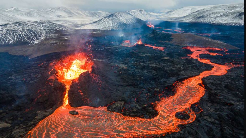
There is an island in the North Atlantic that looks like the earth never finished forming. The ground still shifts underfoot, lava flows cool into shapes that seem freshly pressed, and the air carries the faint sulfur of processes that began long before anything lived here. Iceland is not a metaphor for creation. It is creation, still in progress.
The island sits above one of the most geologically active zones on the planet,Iceland volcanic rift, where two of the earth’s tectonic plates pull apart at roughly the pace your fingernails grow. That slow, constant separation has been feeding magma to the surface for 24 million years. What emerged from the ocean is a landscape that scientists describe as a window into the earth’s earliest history, a place where the conditions that once allowed life to appear can still be observed, touched, and measured.
For a week, a small group of researchers and explorers followed the trace of that rift across Iceland’s interior, from the slopes of its most feared volcano to the edge of its largest glacier. What they found was not just geology. It was a timeline, written in rock and ice, of how a planet learns to sustain life.
Iceland Volcanic Spine: The Ridge That Split the World
Iceland exists because of a coincidence that, on a planetary scale, Iceland volcanic rift,borders on the improbable. Most of the Mid-Atlantic Ridge, the underwater mountain chain that runs the length of the Atlantic Ocean, sits quietly on the ocean floor, invisible and unvisited. Iceland is the point where that ridge rises above sea level, pushed upward by the combined force of tectonic spreading and a deep mantle hotspot that bulges the crust from below.
The result is an island that straddles two continents. The North American plate lies to the west, the Eurasian plate to the east, and Iceland occupies the seam between them. Every year, that seam widens by a few centimeters as fresh magma fills the gap from below. The island is, in the most literal sense, being made continuously.
This is not just a curiosity for geologists. It means that Iceland’s rocks are among the youngest on earth’s surface, and that the processes shaping them today are the same ones that shaped the entire planet in its first billion years. Standing on a fresh lava field here is about as close as a person can get to standing on early earth. The landscape is almost entirely mineral. Life, where it appears, is sparse and recent. The parallels with other planets are striking enough that researchers studying Mars have long used Iceland as a reference terrain.
The expedition followed this ridge inland, tracking the geological spine of the island from south to north. Each day brought a new piece of the same story: a planet that has never stopped building itself.
Hekla: The Volcano That Never Fully Sleeps
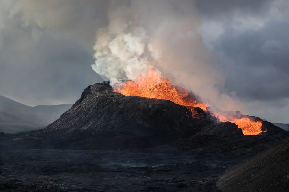
Of all the volcanoes along Iceland’s rift zone, Hekla carries the heaviest reputation. It has erupted more than twenty times in the last thousand years, making it one of the most active in the country. In medieval Icelandic tradition, it was associated with the entrance to hell. That image is easier to understand once you have seen what it can do.
The expedition’s first major stop was at Hekla’s base, where a long lava flow stretches across the hillside like a frozen river. Some of these flows are 150 years old and still look raw, the surface broken and angular, vegetation only beginning to find a foothold at the edges. The mountain itself rises deceptively calmly above them. Hiking trails on its slopes come with a standard recommendation: check seismic activity before you go up. The volcano can move from silence to eruption in under an hour.
Since 2005, instruments have recorded the ground around Hekla slowly inflating, a sign that magma is accumulating in a reservoir roughly ten kilometers below the surface. The island’s volcanic monitoring network, one of the densest in the world, tracks ground deformation, gas emissions, and micro-earthquakes continuously. Scientists know another eruption is coming. They cannot say when.
What Hekla illustrates, beyond its obvious danger, is something more fundamental. Four and a half billion years ago, the entire earth looked something like this: a surface dominated by eruption and mineral chaos, with water arriving from comets and asteroids, becoming trapped in the magma, then released through volcanic activity. That process, repeated across millions of years, eventually created the conditions for chemistry to become biology. The lava cooling on Hekla’s slopes is a slow-motion replay of the earth’s own beginning.
Where Geology Becomes Biology
The question that brought the scientists to Iceland was not simply about rocks. It was about the moment when rocks became relevant to life, when a purely mineral world crossed a threshold and started producing the conditions for something living to exist.
That threshold, it turns out, is harder to locate than anyone expected. For a long time, the assumption was that life began at the surface, in shallow water, under sunlight. Recent research has complicated that picture considerably. In the hydrothermal environments of volcanic regions, scientists have found microbial life thriving in conditions that would have seemed hostile by any standard definition: extreme heat, high acidity, no light, no oxygen. More surprisingly, studies of the earth’s crust have shown that more living biomass may exist in the first few kilometers below the surface than in all ecosystems above it.
Iceland’s hydrothermal fields are among the best places on earth to study this boundary. The fumaroles, the hot springs, the mineral-rich fluids seeping through fractured basalt all create micro-environments where chemistry runs fast and life finds ways to hold on. The biofilms and microbial communities found here are not exotic curiosities. They are likely close relatives of the organisms that first colonized the early earth.
For the expedition’s geomicrobiologist, each sample collected from a hydrothermal vent or a mineral surface represented a potential data point in one of science’s oldest open questions. The tools were modest: collection vials, sterile swabs, a field notebook. The implications were not. If life can establish itself in Iceland’s volcanic crust today, the same chemistry was almost certainly at work four billion years ago, on a planet that looked very much like this one.
The Town That Fought the Lava
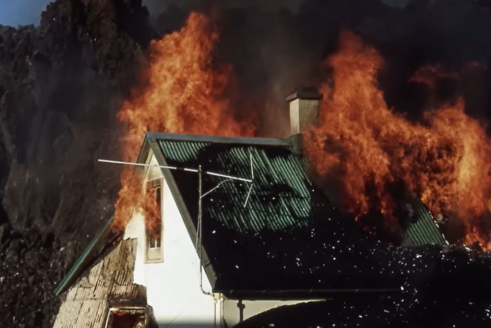
In January 1973, the island of Heimaey, off Iceland’s southern coast, woke to an eruption that no one had predicted. A fissure roughly a kilometer and a half long opened overnight on the eastern edge of the island. The volcano that emerged from it, later named Eldfell, had been dormant for five thousand years. Within hours, the island’s five thousand residents were evacuated by fishing boat to the mainland. It was one of the most orderly emergency evacuations in Icelandic history, partly because the fishing fleet happened to be in harbor that night due to bad weather.
What followed over the next five months was something between a natural disaster and an improvised experiment. Lava flows advanced steadily toward the harbor, the economic lifeline of the island and one of the most important fishing ports in the North Atlantic. Losing it would have meant losing Heimaey’s reason to exist. A group of residents and scientists decided to try something that had never been attempted at scale: cooling the lava with seawater to slow and redirect its advance.
The operation required pumping millions of liters of cold seawater onto the lava front, day and night, for weeks. It was physically brutal and logistically chaotic. Against most expectations, it worked. The lava slowed, hardened, and eventually stopped short of closing the harbor entrance. The port was saved. The island was repopulated within a year.
Today a museum built over the ruins of houses swallowed by the eruption preserves the memory of those months. Heimaey is still inhabited, still fishing, and now permanently larger, the eruption having added two square kilometers of new land to the island. It is one of the clearest examples of what living with Icelandic geology actually means: not safety, but adaptation.
Iceland Volcanic Spine: Ice Over Fire
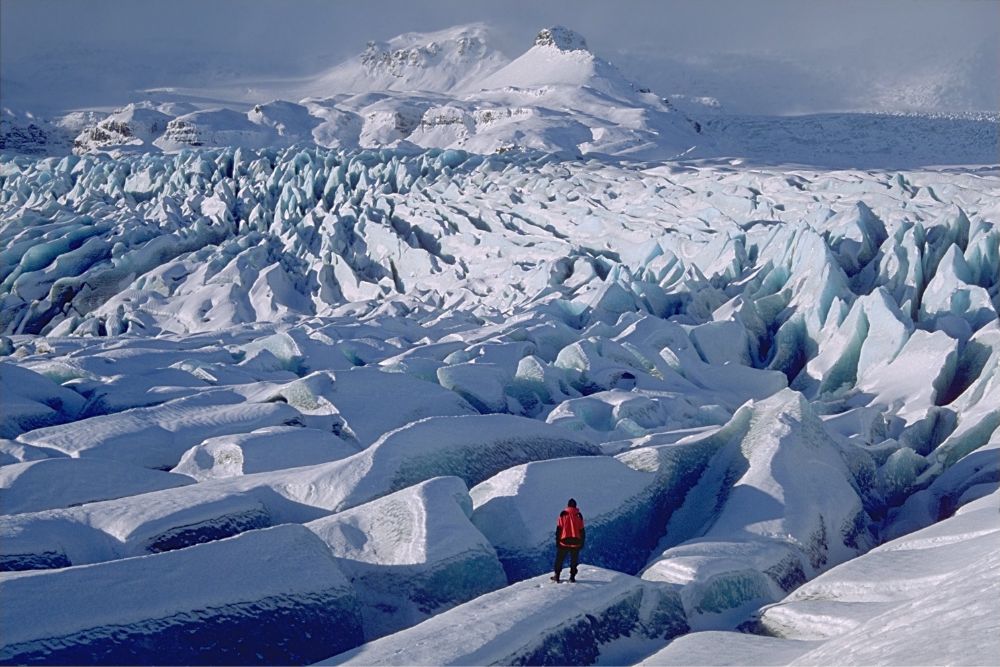
At the end of the expedition’s sixth day, the group reached Vatnaجökull. It is the largest glacier in Iceland and one of the largest in Europe, a sheet of ice up to a kilometer thick covering roughly eight percent of the island’s total surface. From a distance it looks permanent, ancient, immovable. The science underneath it tells a different story.
Beneath Vatnaجökull sits one of Iceland’s most significant magma reservoirs, fed directly by the same mantle hotspot that pushed the island above sea level in the first place. The heat from below melts the base of the glacier continuously, creating subglacial lakes that can drain catastrophically when pressure builds to a breaking point. These glacial outburst floods, known in Icelandic as jökulhlaups, have shaped the landscape south of the glacier into a vast plain of black sand and braided rivers, one of the most otherworldly terrains on the island.
The relationship between the glacier and the volcano beneath it is not stable. As the ice sheet thins due to warming temperatures, the reduction in weight on the crust is measurable, and researchers have observed that reduced glacial pressure can influence volcanic activity below. The ice and the fire are not separate systems. They are coupled, each responding to changes in the other over timescales that range from days to centuries.
Standing at the glacier’s edge, the expedition reached what felt like a natural conclusion to the week’s journey. The hotspot below Vatnaجökull is the engine behind much of Iceland’s activity, the deep source that has been driving eruptions, building crust, and shaping the island since long before any human set foot here. Everything the group had observed over six days, the lava fields, the fumaroles, the hydrothermal vents, traced back to this.
A Country Without a Thermostat
Iceland has no stable baseline. The ground inflates and deflates with magma movements. Rivers rise overnight when a subglacial eruption melts ice faster than it can drain. A farm that has stood for three generations can be buried in an afternoon. The Icelandic relationship with this landscape is not one of control. It is one of continuous negotiation.
Agriculture here has always operated under that constraint. The soils around volcanic zones are exceptionally fertile, enriched by centuries of ash deposits, which is precisely why farmers have returned to the same areas after eruptions rather than abandoning them. Some farms have been relocated multiple times following earthquakes or lava advances. The attachment is not irrational. It is a calculation, made over generations, that the land is worth the risk.
The monitoring infrastructure built around that risk is now among the most sophisticated in the world. Iceland’s network of seismometers, GPS stations, and gas sensors covers the entire island and feeds data continuously to research institutions. When magma begins moving, the signals appear days or weeks in advance: the ground swells, small earthquakes cluster along fault lines, the chemistry of fumarole gases shifts. In March 2021, an eruption broke through near Reykjavik on the Reykjanes peninsula, the first in that area in nearly eight hundred years. Scientists had been tracking the magma’s ascent for more than a year before the surface opened.
That eruption lit up the sky above the capital. It was dangerous in the abstract and spectacular in practice, close enough to the city that people drove out to watch from a safe distance. It was also, for volcanologists, confirmation that the Reykjanes peninsula had entered a new period of activity likely to continue for decades. A new magmatic pulse has already been detected in the same zone.
The Icelanders have a phrase for the attitude this requires. Roughly translated, it means living in accordance with the environment. Not mastering it, not fearing it, but reading it carefully and adjusting accordingly.
An Open Book
Iceland does not offer the comfort of finished landscapes. There are no ancient, stable plains here, no geology that has settled into permanence. What the island offers instead is process, visible and ongoing, the earth doing in real time what it has always done, building crust, releasing heat, cycling water and minerals through systems that predate any life by billions of years.
That is what makes it useful, not just as a destination but as a way of understanding the planet. The questions the expedition came to ask, about the origins of life, about the conditions that allow biology to emerge from chemistry, about the relationship between volcanic heat and living organisms, are not questions with clean answers. But Iceland makes them concrete. The fumarole you can smell, the lava field you can walk across, the glacier sitting over a magma reservoir you cannot see but can measure: these are not illustrations of scientific concepts. They are the concepts themselves, at full scale, in the open air.
Every five years on average, Iceland produces an eruption. The intervals vary, the locations shift, the intensity ranges from a quiet lava leak to an ash column that grounds aircraft across Europe. What does not change is the underlying dynamic: a planet still releasing the heat of its own formation, still building surface from depth, still running the same geological processes that set the stage for everything that came after.
Traveling through Iceland with that in mind changes what you see. The black sand is not just black sand. The steam rising from a roadside vent is not just steam. The glacier is not just ice. Each of them is a chapter in a story that started 4.5 billion years ago and has not reached its ending. The island is not a museum of earth history. It is earth history, still being written.
The People Behind the Expedition
The week across Iceland’s volcanic interior was shaped by the people who made it possible.
Charles Frankel, a geologist with deep familiarity with Icelandic terrain, guided the scientific reading of the landscape, connecting the volcanic formations underfoot to broader questions about planetary geology and, through his work with the Mars Society, to what those formations say about other worlds.
Bénédicte Menez, a geomicrobiologist specializing in microbial life in extreme environments, led the sampling work at hydrothermal sites, bringing to the expedition the specific question of how and where life first takes hold in a mineral world.
Olivier Grunewald, a photographer who traces his own vocation to an earlier encounter with Iceland’s volcanic landscapes, documented the journey.
Berglind, a Franco-Icelandic horsewoman, accompanied the group on horseback through terrain that remains most naturally navigated that way. A mountain guide ensured the group’s safety across six days of weather and ground conditions that changed without warning. these adventure was documented by ART TV