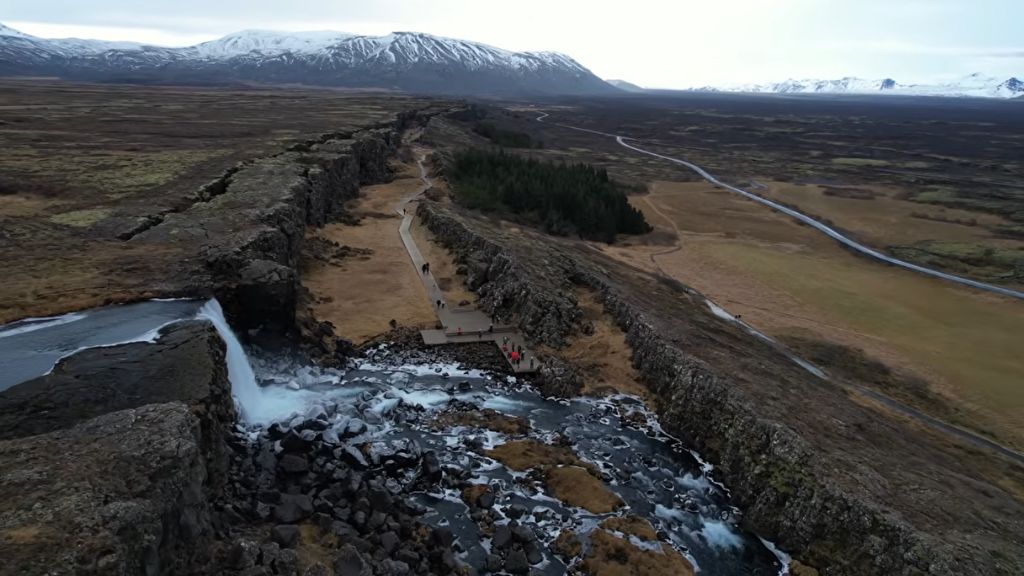
Öxarárfoss — the rift waterfall of Þingvellir

Iceland’s Most Geologically Significant Places: A Thoughtful Guide for Curious Travelers

Most travel guides will show you beautiful Iceland’s geological places. This one will show you its most eloquent ones. The places where the Earth speaks most clearly. Where millions of years of history compress into a single view, a single sound, a single step across a fault line.

Iceland sits on the Mid-Atlantic Ridge, the seam where two tectonic plates pull apart at roughly the pace your fingernails grow. That slow, relentless tension produces volcanoes, rifts, geysers, and glaciers sitting on top of magma chambers. It is one of the most geologically active places on the planet, and it shows.

Iceland’s geological places are unlike anywhere else on Earth, not because they are the most dramatic, but because they are the most legible. This guide is not a ranking. It is an invitation to understand why certain places here carry more weight than others, and what each one is actually trying to say.

What Makes a Place Worth Understanding, Not Just Visiting

There are thousands of Iceland’s geological places: A Guide to the Island’s Most Significant Sites. Waterfalls, black sand beaches, steaming fumaroles. Most are genuinely spectacular. But spectacle and significance are not the same thing.

At Geonatra, a place earns a spot in a guide like this through three criteria. First, geological uniqueness: does this place show something the Earth does nowhere else, or nowhere else so visibly? Second, narrative accessibility: can a curious traveler with no science background grasp what they are looking at? Third, transmissible lesson: does the place leave you with something you can carry away and explain to someone else?

Some of Iceland’s most photographed landscapes don’t meet all three. They are beautiful without being legible. The places below are both.

Seven Places That Teach You How the Earth Works

1. Reykjanes Peninsula — Where the Plates Pull Apart

The Reykjanes Peninsula is the only place on Earth where the Mid-Atlantic Ridge rises above sea level and is accessible on foot. You can stand on a bridge between the North American and Eurasian plates, look down into the rift, and understand tectonics not as a concept but as a physical reality. The peninsula has been erupting repeatedly since 2021, with lava fields still cooling as visitors walk alongside them. This is not geology as history. It is geology as present tense.

The Geological Lesson The ground you stand on is moving. Right now. Two continents are separating beneath Iceland at about 2 centimeters per year, and Reykjanes is where you can see exactly how that happens.

2. Silfra Rift — The Space Between Two Continents

Silfra is a fissure filled with glacial meltwater that has filtered through lava rock for decades. The water reaches a visibility of over 100 meters, making it one of the clearest dive and snorkel sites in the world. But the geological significance goes further. Silfra sits directly in the rift zone between the North American and Eurasian plates. When you reach out both arms underwater, you are touching two separate continents. That is not a metaphor.

The Geological Lesson Continental drift is not something that happened. It is something that is happening. Silfra is the gap it leaves behind.

3. Vatnajökull; Fire Beneath the Ice

Vatnajökull is Europe’s largest glacier by volume, covering roughly 8 percent of Iceland’s land area. Beneath it, several active volcanoes, including Grímsvötn and Bárðarbunga, erupt periodically, melting ice from below and triggering jökulhlaups: sudden glacial floods that reshape riverbeds in hours. The glacier is also retreating steadily each year. More on this in our dedicated article: Vatnajokull: What Happens When a Glacier Sits on Top of a Volcano.

The Geological Lesson Ice and fire are not opposites in Iceland. They are partners in one of the Earth’s most powerful cycles of destruction and renewal.

4. Dettifoss — The Force of Patient Water

Dettifoss discharges more water per second than any other waterfall in Europe. What makes it remarkable is not the volume but the context: it has carved the Jökulsárgljúfur canyon out of basalt, one of the hardest rock types on Earth, over approximately 10,000 years. The scale of erosion visible here is an argument about time, not power. Water does not fight rock. It outlasts it. More on the geology: Dettifoss: the waterfall that moves.

The Geological Lesson Water is the softest force in nature. Given enough time, it carves through the hardest rock on Earth.

5. Lake Mývatn — A Geothermal Ecosystem

Lake Mývatn was born roughly 2,300 years ago from a large lava eruption that dammed a river and created a shallow, nutrient-rich lake. The geothermal heat persisting beneath the lake bottom produces conditions that support extraordinary biodiversity: more species of duck breed here than anywhere else in the world. Around the lake, pseudo-craters formed where lava flowed over wetland, trapping steam that exploded upward. At the nearby Hverir geothermal field, boiling mud pits and sulfuric fumaroles make visible the heat that still drives everything here.

The Geological Lesson A volcanic catastrophe 2,300 years ago created one of the most biodiverse lakes in the Northern Hemisphere. Destruction and creation, in geology, are often the same event. that created also Iceland’s geological places: A Guide to the Island’s Most Significant Sites

6. Snæfellsnes — The Volcano That Inspired a Journey to the Center of the Earth

Snæfellsjökull, the glacier-capped stratovolcano at the tip of the Snæfellsnes Peninsula, is the entrance point Jules Verne chose for his 1864 novel. That choice was not random. The volcano sits at the junction of several tectonic and volcanic systems, and the peninsula itself is a cross-section of Iceland’s geological history, from ancient basalt flows to recent lava fields. The glacier capping the summit is retreating and may disappear within decades. More context: Snaefellsnes: The Volcano That Inspired Jules Verne and Shaped an Island’s Edge.

The Geological Lesson Geology doesn’t only shape landscapes. Sometimes it shapes stories, imagination, and entire literary traditions.

7. Askja and the Highlands — The Earth Without Life

The central highlands of Iceland, and the Askja caldera in particular, are among the most desolate landscapes accessible to travelers anywhere in the world. NASA sent Apollo astronauts here in 1965 to train for the lunar surface. The interior is a landscape of black rhyolite, obsidian, and tephra with almost no vegetation, shaped entirely by volcanic forces. Askja last erupted in 1961, within living memory. Inside the caldera sits Víti, a geothermal crater lake of milky blue water. The contrast with the surrounding moonscape is as startling as it is beautiful.

The Geological Lesson Iceland’s central highlands look the way Earth looked before life took hold. They are a window into deep time, accessible in a single afternoon drive.

Beyond Season One: Places That Will Teach You Even More

The seven places above form the core of what Iceland can teach a curious traveler. But the island is not finished making its argument. Season 2 will look deeper, and further west.

The Westfjords hold some of the oldest exposed rock in Iceland, around 16 million years of layered basalt eroded into deep, quiet fjords. They show what Iceland will look like in millions of years: not fire and upheaval, but patience and slow wearing down.

Reykjavik is a capital built almost entirely on lava that is younger than many human civilizations. Its streets cross ancient flow boundaries. It is urban geology hiding in plain sight.

Grímsey Island sits precisely on the Arctic Circle, a coincidence of geography that becomes a geological and astronomical meditation. The island is also slowly moving northward with the tectonic plate it rides on.

These places are at the heart of our Season 2.

What Iceland’s Most Significant Places Share

Every place on this list is fragile. Not despite its geological power but because of it. Active volcanic landscapes change fast. Glaciers retreat. Rifts widen. The more dramatic a geological feature, the more time-sensitive the experience of it.

They also share something rarer: each one requires attention to be understood. A quick photograph captures the surface. The lesson only emerges when you slow down and ask what you are actually looking at.

And all of them tell a story that began long before humans arrived on this island. The youngest landscape here is older than any human civilization. That perspective, once you feel it, does not leave easily.

Iceland’s geological places also raise a quieter question: how do we travel through landscapes like these without wearing them down? That question runs beneath everything we write at Geonatra, and it will be central to the articles that follow in May.

Iceland doesn’t need you to be a geologist to understand it. It just needs you to be curious, attentive, and willing to look, really look, at what the Earth has been building here for millions of years. Every place in this guide will reward that attention.

For a practical overview of how to connect these places into a single journey, the Ring Road: 7 geological stops that explain how Iceland was built is a good place to start.

Frequently Asked Questions

What is the most geologically unique place in Iceland?

The Reykjanes Peninsula is arguably the most geologically unique, as it is the only place on Earth where the Mid-Atlantic Ridge is accessible on land. However, uniqueness depends on what you are looking for: Silfra offers the rare experience of physically touching two tectonic plates, while Vatnajökull presents the coexistence of active volcanism and glaciation at a scale found nowhere else in Europe.

Which Iceland geological sites are UNESCO protected?

Vatnajökull National Park received UNESCO World Heritage status in 2019, recognized for its outstanding geological and natural values. The park includes the glacier, several active volcanoes, and the major river systems fed by glacial meltwater. Þingvellir National Park, which sits directly on the Mid-Atlantic Rift, is also a UNESCO World Heritage Site, with both geological and historical designations.

Can I visit Iceland’s geological sites without a guide?

Most sites listed here are accessible independently, including Dettifoss, Snæfellsnes, and the exterior of Vatnajökull. Silfra requires a certified dive or snorkel operator due to cold water temperatures. Askja and the central highlands require a 4WD vehicle and are typically accessible from late June to early September only. For volcanic zones with active eruptions, always check current safety advisories from the Icelandic Met Office before visiting.

What is the best geological destination in Iceland for first-time visitors?

Snæfellsnes is often the best starting point. It concentrates an extraordinary range of geological features, from the glacier-capped volcano to lava tubes, basalt cliffs, and coastal erosion, within a single peninsula that can be driven in a day. It is also less crowded than the Golden Circle while offering comparable geological depth.

What This Place Teaches

The Geological Lesson Iceland is not an exception to how the Earth works. It is the Earth working in plain sight. Every volcano, glacier, and rift here is a version of a process happening everywhere on the planet, just slower and mostly underground.

For Young Explorers

Pick any two places from this article that seem completely different. Write one sentence about what they have in common geologically. (Hint: they all connect to the same thing happening beneath Iceland right now.)

The Deep Time Angle

Iceland is one of the youngest landmasses on Earth, most of it less than 20 million years old. The lava fields on the Reykjanes Peninsula that erupted in 2021 are younger than most people reading this article. On a planet that is 4.5 billion years old, Iceland is still a first draft.

Further Reading

For scientific context on Iceland’s volcanic and tectonic systems, the Icelandic Meteorological Office publishes real-time seismic and volcanic monitoring data, including eruption bulletins and deformation measurements. It is the primary scientific reference for everything happening beneath these landscapes today.Most travel guides will show you Iceland’s most beautiful places. This one will show you its most eloquent ones. The places where the Earth speaks most clearly. Where millions of years of history compress into a single view, a single sound, a single step across a fault line.

Iceland sits on the Mid-Atlantic Ridge, the seam where two tectonic plates pull apart at roughly the pace your fingernails grow. That slow, relentless tension produces volcanoes, rifts, geysers, and glaciers sitting on top of magma chambers. It is one of the most geologically active places on the planet, and it shows.

Iceland’s geological places are unlike anywhere else on Earth, not because they are the most dramatic, but because they are the most legible. This guide is not a ranking. It is an invitation to understand why certain places here carry more weight than others, and what each one is actually trying to say.

What Makes a Place Worth Understanding, Not Just Visiting

There are thousands of beautiful places in Iceland. Waterfalls, black sand beaches, steaming fumaroles. Most are genuinely spectacular. But spectacle and significance are not the same thing.

At Geonatra, a place earns a spot in a guide like this through three criteria. First, geological uniqueness: does this place show something the Earth does nowhere else, or nowhere else so visibly? Second, narrative accessibility: can a curious traveler with no science background grasp what they are looking at? Third, transmissible lesson: does the place leave you with something you can carry away and explain to someone else?

Some of Iceland’s most photographed landscapes don’t meet all three. They are beautiful without being legible. The places below are both.

Seven Places That Teach You How the Earth Works

1. Reykjanes Peninsula — Where the Plates Pull Apart

The Reykjanes Peninsula is the only place on Earth where the Mid-Atlantic Ridge rises above sea level and is accessible on foot. You can stand on a bridge between the North American and Eurasian plates, look down into the rift, and understand tectonics not as a concept but as a physical reality. The peninsula has been erupting repeatedly since 2021, with lava fields still cooling as visitors walk alongside them. This is not geology as history. It is geology as present tense.

The Geological Lesson The ground you stand on is moving. Right now. Two continents are separating beneath Iceland at about 2 centimeters per year, and Reykjanes is where you can see exactly how that happens.

2. Silfra Rift — The Space Between Two Continents

Silfra is a fissure filled with glacial meltwater that has filtered through lava rock for decades. The water reaches a visibility of over 100 meters, making it one of the clearest dive and snorkel sites in the world. But the geological significance goes further. Silfra sits directly in the rift zone between the North American and Eurasian plates. When you reach out both arms underwater, you are touching two separate continents. That is not a metaphor.

The Geological Lesson Continental drift is not something that happened. It is something that is happening. Silfra is the gap it leaves behind.

3. Vatnajökull — Fire Beneath the Ice

Vatnajökull is Europe’s largest glacier by volume, covering roughly 8 percent of Iceland’s land area. Beneath it, several active volcanoes, including Grímsvötn and Bárðarbunga, erupt periodically, melting ice from below and triggering jökulhlaups: sudden glacial floods that reshape riverbeds in hours. The glacier is also retreating steadily each year. More on this in our dedicated article: Vatnajokull: What Happens When a Glacier Sits on Top of a Volcano.

The Geological Lesson Ice and fire are not opposites in Iceland. They are partners in one of the Earth’s most powerful cycles of destruction and renewal.

4. Dettifoss — The Force of Patient Water

Dettifoss discharges more water per second than any other waterfall in Europe. What makes it remarkable is not the volume but the context: it has carved the Jökulsárgljúfur canyon out of basalt, one of the hardest rock types on Earth, over approximately 10,000 years. The scale of erosion visible here is an argument about time, not power. Water does not fight rock. It outlasts it. More on the geology: Dettifoss: the waterfall that moves.

The Geological Lesson Water is the softest force in nature. Given enough time, it carves through the hardest rock on Earth.

5. Lake Mývatn — A Geothermal Ecosystem

Lake Mývatn was born roughly 2,300 years ago from a large lava eruption that dammed a river and created a shallow, nutrient-rich lake. The geothermal heat persisting beneath the lake bottom produces conditions that support extraordinary biodiversity: more species of duck breed here than anywhere else in the world. Around the lake, pseudo-craters formed where lava flowed over wetland, trapping steam that exploded upward. At the nearby Hverir geothermal field, boiling mud pits and sulfuric fumaroles make visible the heat that still drives everything here.

The Geological Lesson A volcanic catastrophe 2,300 years ago created one of the most biodiverse lakes in the Northern Hemisphere. Destruction and creation, in geology, are often the same event.

6. Snæfellsnes — The Volcano That Inspired a Journey to the Center of the Earth

Snæfellsjökull, the glacier-capped stratovolcano at the tip of the Snæfellsnes Peninsula, is the entrance point Jules Verne chose for his 1864 novel. That choice was not random. The volcano sits at the junction of several tectonic and volcanic systems, and the peninsula itself is a cross-section of Iceland’s geological history, from ancient basalt flows to recent lava fields. The glacier capping the summit is retreating and may disappear within decades. More context: Snaefellsnes: The Volcano That Inspired Jules Verne and Shaped an Island’s Edge.

The Geological Lesson Geology doesn’t only shape landscapes. Sometimes it shapes stories, imagination, and entire literary traditions.

7. Askja and the Highlands — The Earth Without Life

The central highlands of Iceland, and the Askja caldera in particular, are among the most desolate landscapes accessible to travelers anywhere in the world. NASA sent Apollo astronauts here in 1965 to train for the lunar surface. The interior is a landscape of black rhyolite, obsidian, and tephra with almost no vegetation, shaped entirely by volcanic forces. Askja last erupted in 1961, within living memory. Inside the caldera sits Víti, a geothermal crater lake of milky blue water. The contrast with the surrounding moonscape is as startling as it is beautiful.

The Geological Lesson Iceland’s central highlands look the way Earth looked before life took hold. They are a window into deep time, accessible in a single afternoon drive.

Beyond Season One: Places That Will Teach You Even More

The seven places above form the core of what Iceland can teach a curious traveler. But the island is not finished making its argument. Season 2 will look deeper, and further west.

The Westfjords hold some of the oldest exposed rock in Iceland, around 16 million years of layered basalt eroded into deep, quiet fjords. They show what Iceland will look like in millions of years: not fire and upheaval, but patience and slow wearing down.

Reykjavik is a capital built almost entirely on lava that is younger than many human civilizations. Its streets cross ancient flow boundaries. It is urban geology hiding in plain sight.

Grímsey Island sits precisely on the Arctic Circle, a coincidence of geography that becomes a geological and astronomical meditation. The island is also slowly moving northward with the tectonic plate it rides on.

These places are at the heart of our Season 2.

What Iceland’s Most Significant Places Share

Every place on this list is fragile. Not despite its geological power but because of it. Active volcanic landscapes change fast. Glaciers retreat. Rifts widen. The more dramatic a geological feature, the more time-sensitive the experience of it.

They also share something rarer: each one requires attention to be understood. A quick photograph captures the surface. The lesson only emerges when you slow down and ask what you are actually looking at.

And all of them tell a story that began long before humans arrived on this island. The youngest landscape here is older than any human civilization. That perspective, once you feel it, does not leave easily.

Iceland’s geological places also raise a quieter question: how do we travel through landscapes like these without wearing them down? That question runs beneath everything we write at Geonatra, and it will be central to the articles that follow in May.

Iceland doesn’t need you to be a geologist to understand it. It just needs you to be curious, attentive, and willing to look, really look, at what the Earth has been building here for millions of years. Every place in this guide will reward that attention.

For a practical overview of how to connect these Iceland’s Geological Places: A Guide to the Island’s Most Significant Sites places into a single journey, the Ring Road: 7 geological stops that explain how Iceland was built is a good place to start.

Frequently Asked Questions

What is the most geologically unique place in Iceland?

The Reykjanes Peninsula is arguably the most geologically unique, as it is the only place on Earth where the Mid-Atlantic Ridge is accessible on land. However, uniqueness depends on what you are looking for: Silfra offers the rare experience of physically touching two tectonic plates, while Vatnajökull presents the coexistence of active volcanism and glaciation at a scale found nowhere else in Europe.

Which Iceland geological sites are UNESCO protected?

Vatnajökull National Park received UNESCO World Heritage status in 2019, recognized for its outstanding geological and natural values. The park includes the glacier, several active volcanoes, and the major river systems fed by glacial meltwater. Þingvellir National Park, which sits directly on the Mid-Atlantic Rift, is also a UNESCO World Heritage Site, with both geological and historical designations.

Can I visit Iceland’s geological sites without a guide?

Most sites listed here are accessible independently, including Dettifoss, Snæfellsnes, and the exterior of Vatnajökull. Silfra requires a certified dive or snorkel operator due to cold water temperatures. Askja and the central highlands require a 4WD vehicle and are typically accessible from late June to early September only. For volcanic zones with active eruptions, always check current safety advisories from the Icelandic Met Office before visiting.

What is the best geological destination in Iceland for first-time visitors?

Snæfellsnes is often the best starting point. It concentrates an extraordinary range of geological features, from the glacier-capped volcano to lava tubes, basalt cliffs, and coastal erosion, within a single peninsula that can be driven in a day. It is also less crowded than the Golden Circle while offering comparable geological depth.

What This Place Teaches

The Geological Lesson Iceland is not an exception to how the Earth works. It is the Earth working in plain sight. Every volcano, glacier, and rift here is a version of a process happening everywhere on the planet, just slower and mostly underground.

For Young Explorers

Pick any two places from this article that seem completely different. Write one sentence about what they have in common geologically. (Hint: they all connect to the same thing happening beneath Iceland right now.)

The Deep Time Angle

Iceland is one of the youngest landmasses on Earth, most of it less than 20 million years old. The lava fields on the Reykjanes Peninsula that erupted in 2021 are younger than most people reading this article. On a planet that is 4.5 billion years old, Iceland is still a first draft.

Further Reading

For scientific context on Iceland’s volcanic and tectonic systems, the Icelandic Meteorological Office publishes real-time seismic and volcanic monitoring data, including eruption bulletins and deformation measurements. It is the primary scientific reference for everything happening beneath these landscapes today.Most travel guides will show you Iceland’s most beautiful places. This one will show you its most eloquent ones. The places where the Earth speaks most clearly. Where millions of years of history compress into a single view, a single sound, a single step across a fault line.

Iceland sits on the Mid-Atlantic Ridge, the seam where two tectonic plates pull apart at roughly the pace your fingernails grow. That slow, relentless tension produces volcanoes, rifts, geysers, and glaciers sitting on top of magma chambers. It is one of the most geologically active places on the planet, and it shows.

Iceland’s geological places are unlike anywhere else on Earth, not because they are the most dramatic, but because they are the most legible. This guide is not a ranking. It is an invitation to understand why certain places here carry more weight than others, and what each one is actually trying to say.

What Makes a Place Worth Understanding, Not Just Visiting

There are thousands of beautiful places in Iceland. Waterfalls, black sand beaches, steaming fumaroles. Most are genuinely spectacular. But spectacle and significance are not the same thing.

At Geonatra, a place earns a spot in a guide like this through three criteria. First, geological uniqueness: does this place show something the Earth does nowhere else, or nowhere else so visibly? Second, narrative accessibility: can a curious traveler with no science background grasp what they are looking at? Third, transmissible lesson: does the place leave you with something you can carry away and explain to someone else?

Some of Iceland’s most photographed landscapes don’t meet all three. They are beautiful without being legible. The places below are both.

Seven Places That Teach You How the Earth Works

1. Reykjanes Peninsula — Where the Plates Pull Apart

The Reykjanes Peninsula is the only place on Earth where the Mid-Atlantic Ridge rises above sea level and is accessible on foot. You can stand on a bridge between the North American and Eurasian plates, look down into the rift, and understand tectonics not as a concept but as a physical reality. The peninsula has been erupting repeatedly since 2021, with lava fields still cooling as visitors walk alongside them. This is not geology as history. It is geology as present tense.

The Geological Lesson The ground you stand on is moving. Right now. Two continents are separating beneath Iceland at about 2 centimeters per year, and Reykjanes is where you can see exactly how that happens.

2. Silfra Rift — The Space Between Two Continents

Silfra is a fissure filled with glacial meltwater that has filtered through lava rock for decades. The water reaches a visibility of over 100 meters, making it one of the clearest dive and snorkel sites in the world. But the geological significance goes further. Silfra sits directly in the rift zone between the North American and Eurasian plates. When you reach out both arms underwater, you are touching two separate continents. That is not a metaphor.

The Geological Lesson Continental drift is not something that happened. It is something that is happening. Silfra is the gap it leaves behind.

3. Vatnajökull — Fire Beneath the Ice

Vatnajökull is Europe’s largest glacier by volume, covering roughly 8 percent of Iceland’s land area. Beneath it, several active volcanoes, including Grímsvötn and Bárðarbunga, erupt periodically, melting ice from below and triggering jökulhlaups: sudden glacial floods that reshape riverbeds in hours. The glacier is also retreating steadily each year. More on this in our dedicated article: Vatnajokull: What Happens When a Glacier Sits on Top of a Volcano.

The Geological Lesson Ice and fire are not opposites in Iceland. They are partners in one of the Earth’s most powerful cycles of destruction and renewal.

4. Dettifoss — The Force of Patient Water

Dettifoss discharges more water per second than any other waterfall in Europe. What makes it remarkable is not the volume but the context: it has carved the Jökulsárgljúfur canyon out of basalt, one of the hardest rock types on Earth, over approximately 10,000 years. The scale of erosion visible here is an argument about time, not power. Water does not fight rock. It outlasts it. More on the geology: Dettifoss: the waterfall that moves.

The Geological Lesson Water is the softest force in nature. Given enough time, it carves through the hardest rock on Earth.

5. Lake Mývatn — A Geothermal Ecosystem

Lake Mývatn was born roughly 2,300 years ago from a large lava eruption that dammed a river and created a shallow, nutrient-rich lake. The geothermal heat persisting beneath the lake bottom produces conditions that support extraordinary biodiversity: more species of duck breed here than anywhere else in the world. Around the lake, pseudo-craters formed where lava flowed over wetland, trapping steam that exploded upward. At the nearby Hverir geothermal field, boiling mud pits and sulfuric fumaroles make visible the heat that still drives everything here.

The Geological Lesson A volcanic catastrophe 2,300 years ago created one of the most biodiverse lakes in the Northern Hemisphere. Destruction and creation, in geology, are often the same event.

6. Snæfellsnes — The Volcano That Inspired a Journey to the Center of the Earth

Snæfellsjökull, the glacier-capped stratovolcano at the tip of the Snæfellsnes Peninsula, is the entrance point Jules Verne chose for his 1864 novel. That choice was not random. The volcano sits at the junction of several tectonic and volcanic systems, and the peninsula itself is a cross-section of Iceland’s geological history, from ancient basalt flows to recent lava fields. The glacier capping the summit is retreating and may disappear within decades. More context: Snaefellsnes: The Volcano That Inspired Jules Verne and Shaped an Island’s Edge.

The Geological Lesson Geology doesn’t only shape landscapes. Sometimes it shapes stories, imagination, and entire literary traditions.

7. Askja and the Highlands — The Earth Without Life

The central highlands of Iceland, and the Askja caldera in particular, are among the most desolate landscapes accessible to travelers anywhere in the world. NASA sent Apollo astronauts here in 1965 to train for the lunar surface. The interior is a landscape of black rhyolite, obsidian, and tephra with almost no vegetation, shaped entirely by volcanic forces. Askja last erupted in 1961, within living memory. Inside the caldera sits Víti, a geothermal crater lake of milky blue water. The contrast with the surrounding moonscape is as startling as it is beautiful.

The Geological Lesson Iceland’s central highlands look the way Earth looked before life took hold. They are a window into deep time, accessible in a single afternoon drive.
pseudo craters at skútustaðir, lake mývatn
A cluster of grass-covered pseudo-craters at Skútustaðir on the southern shore of Lake Mývatn, formed thousands of years ago when lava flowed over the wetland and trapped steam explosions beneath the surface.

Beyond Season One: Places That Will Teach You Even More

The seven places above form the core of what Iceland can teach a curious traveler. But the island is not finished making its argument. Season 2 will look deeper, and further west.

The Westfjords hold some of the oldest exposed rock in Iceland, around 16 million years of layered basalt eroded into deep, quiet fjords. They show what Iceland will look like in millions of years: not fire and upheaval, but patience and slow wearing down.

Reykjavik is a capital built almost entirely on lava that is younger than many human civilizations. Its streets cross ancient flow boundaries. It is urban geology hiding in plain sight.

Grímsey Island sits precisely on the Arctic Circle, a coincidence of geography that becomes a geological and astronomical meditation. The island is also slowly moving northward with the tectonic plate it rides on.

These places are at the heart of our Season 2.

What Iceland’s Most Significant Places Share

Every place on this list is fragile. Not despite its geological power but because of it. Active volcanic landscapes change fast. Glaciers retreat. Rifts widen. The more dramatic a geological feature, the more time-sensitive the experience of it.

They also share something rarer: each one requires attention to be understood. A quick photograph captures the surface. The lesson only emerges when you slow down and ask what you are actually looking at.

And all of them tell a story that began long before humans arrived on this island. The youngest landscape here is older than any human civilization. That perspective, once you feel it, does not leave easily.

Iceland’s geological places also raise a quieter question: how do we travel through landscapes like these without wearing them down? That question runs beneath everything we write at Geonatra, and it will be central to the articles that follow in May.

Iceland doesn’t need you to be a geologist to understand it. It just needs you to be curious, attentive, and willing to look, really look, at what the Earth has been building here for millions of years. Every place in this guide will reward that attention.

For a practical overview of how to connect these places into a single journey, the Ring Road: 7 geological stops that explain how Iceland was built is a good place to start.

Frequently Asked Questions

What is the most geologically unique place in Iceland?

The Reykjanes Peninsula is arguably the most geologically unique, as it is the only place on Earth where the Mid-Atlantic Ridge is accessible on land. However, uniqueness depends on what you are looking for: Silfra offers the rare experience of physically touching two tectonic plates, while Vatnajökull presents the coexistence of active volcanism and glaciation at a scale found nowhere else in Europe.

Which Iceland geological sites are UNESCO protected?

Vatnajökull National Park received UNESCO World Heritage status in 2019, recognized for its outstanding geological and natural values. The park includes the glacier, several active volcanoes, and the major river systems fed by glacial meltwater. Þingvellir National Park, which sits directly on the Mid-Atlantic Rift, is also a UNESCO World Heritage Site, with both geological and historical designations.

Can I visit Iceland’s geological sites without a guide?

Most sites listed here are accessible independently, including Dettifoss, Snæfellsnes, and the exterior of Vatnajökull. Silfra requires a certified dive or snorkel operator due to cold water temperatures. Askja and the central highlands require a 4WD vehicle and are typically accessible from late June to early September only. For volcanic zones with active eruptions, always check current safety advisories from the Icelandic Met Office before visiting.

What is the best geological destination in Iceland for first-time visitors?

Snæfellsnes is often the best starting point. It concentrates an extraordinary range of geological features, from the glacier-capped volcano to lava tubes, basalt cliffs, and coastal erosion, within a single peninsula that can be driven in a day. It is also less crowded than the Golden Circle while offering comparable geological depth.

What This Place Teaches

The Geological Lesson Iceland is not an exception to how the Earth works. It is the Earth working in plain sight. Every volcano, glacier, and rift here is a version of a process happening everywhere on the planet, just slower and mostly underground.

For Young Explorers

Pick any two places from this article that seem completely different. Write one sentence about what they have in common geologically. (Hint: they all connect to the same thing happening beneath Iceland right now.)

The Deep Time Angle

Iceland is one of the youngest landmasses on Earth, most of it less than 20 million years old. The lava fields on the Reykjanes Peninsula that erupted in 2021 are younger than most people reading this article. On a planet that is 4.5 billion years old, Iceland is still a first draft.

Further Reading

For scientific context on Iceland’s volcanic and tectonic systems, the Icelandic Meteorological Office publishes real-time seismic and volcanic monitoring data, including eruption bulletins and deformation measurements. It is the primary scientific reference for everything happening beneath these landscapes today.Most travel guides will show you Iceland’s most beautiful places. This one will show you its most eloquent ones. The places where the Earth speaks most clearly. Where millions of years of history compress into a single view, a single sound, a single step across a fault line.

Iceland sits on the Mid-Atlantic Ridge, the seam where two tectonic plates pull apart at roughly the pace your fingernails grow. That slow, relentless tension produces volcanoes, rifts, geysers, and glaciers sitting on top of magma chambers. It is one of the most geologically active places on the planet, and it shows.

Iceland’s geological places are unlike anywhere else on Earth, not because they are the most dramatic, but because they are the most legible. This guide is not a ranking. It is an invitation to understand why certain places here carry more weight than others, and what each one is actually trying to say.

What Makes a Place Worth Understanding, Not Just Visiting

There are thousands of beautiful places in Iceland. Waterfalls, black sand beaches, steaming fumaroles. Most are genuinely spectacular. But spectacle and significance are not the same thing.

At Geonatra, a place earns a spot in a guide like this through three criteria. First, geological uniqueness: does this place show something the Earth does nowhere else, or nowhere else so visibly? Second, narrative accessibility: can a curious traveler with no science background grasp what they are looking at? Third, transmissible lesson: does the place leave you with something you can carry away and explain to someone else?

Some of Iceland’s most photographed landscapes don’t meet all three. They are beautiful without being legible. The places below are both.

Seven Places That Teach You How the Earth Works

1. Reykjanes Peninsula — Where the Plates Pull Apart

The Reykjanes Peninsula is the only place on Earth where the Mid-Atlantic Ridge rises above sea level and is accessible on foot. You can stand on a bridge between the North American and Eurasian plates, look down into the rift, and understand tectonics not as a concept but as a physical reality. The peninsula has been erupting repeatedly since 2021, with lava fields still cooling as visitors walk alongside them. This is not geology as history. It is geology as present tense.

The Geological Lesson The ground you stand on is moving. Right now. Two continents are separating beneath Iceland at about 2 centimeters per year, and Reykjanes is where you can see exactly how that happens.

2. Silfra Rift — The Space Between Two Continents

Silfra is a fissure filled with glacial meltwater that has filtered through lava rock for decades. The water reaches a visibility of over 100 meters, making it one of the clearest dive and snorkel sites in the world. But the geological significance goes further. Silfra sits directly in the rift zone between the North American and Eurasian plates. When you reach out both arms underwater, you are touching two separate continents. That is not a metaphor.

The Geological Lesson Continental drift is not something that happened. It is something that is happening. Silfra is the gap it leaves behind.

3. Vatnajökull — Fire Beneath the Ice

Vatnajökull is Europe’s largest glacier by volume, covering roughly 8 percent of Iceland’s land area. Beneath it, several active volcanoes, including Grímsvötn and Bárðarbunga, erupt periodically, melting ice from below and triggering jökulhlaups: sudden glacial floods that reshape riverbeds in hours. The glacier is also retreating steadily each year. More on this in our dedicated article: Vatnajokull: What Happens When a Glacier Sits on Top of a Volcano.

The Geological Lesson Ice and fire are not opposites in Iceland. They are partners in one of the Earth’s most powerful cycles of destruction and renewal.

4. Dettifoss — The Force of Patient Water

Dettifoss discharges more water per second than any other waterfall in Europe. What makes it remarkable is not the volume but the context: it has carved the Jökulsárgljúfur canyon out of basalt, one of the hardest rock types on Earth, over approximately 10,000 years. The scale of erosion visible here is an argument about time, not power. Water does not fight rock. It outlasts it. More on the geology: Dettifoss: the waterfall that moves.

The Geological Lesson Water is the softest force in nature. Given enough time, it carves through the hardest rock on Earth.

5. Lake Mývatn — A Geothermal Ecosystem

Lake Mývatn was born roughly 2,300 years ago from a large lava eruption that dammed a river and created a shallow, nutrient-rich lake. The geothermal heat persisting beneath the lake bottom produces conditions that support extraordinary biodiversity: more species of duck breed here than anywhere else in the world. Around the lake, pseudo-craters formed where lava flowed over wetland, trapping steam that exploded upward. At the nearby Hverir geothermal field, boiling mud pits and sulfuric fumaroles make visible the heat that still drives everything here.

The Geological Lesson A volcanic catastrophe 2,300 years ago created one of the most biodiverse lakes in the Northern Hemisphere. Destruction and creation, in geology, are often the same event.

6. Snæfellsnes — The Volcano That Inspired a Journey to the Center of the Earth

Snæfellsjökull, the glacier-capped stratovolcano at the tip of the Snæfellsnes Peninsula, is the entrance point Jules Verne chose for his 1864 novel. That choice was not random. The volcano sits at the junction of several tectonic and volcanic systems, and the peninsula itself is a cross-section of Iceland’s geological history, from ancient basalt flows to recent lava fields. The glacier capping the summit is retreating and may disappear within decades. More context: Snaefellsnes: The Volcano That Inspired Jules Verne and Shaped an Island’s Edge.

The Geological Lesson Geology doesn’t only shape landscapes. Sometimes it shapes stories, imagination, and entire literary traditions.

7. Askja and the Highlands — The Earth Without Life

The central highlands of Iceland, and the Askja caldera in particular, are among the most desolate landscapes accessible to travelers anywhere in the world. NASA sent Apollo astronauts here in 1965 to train for the lunar surface. The interior is a landscape of black rhyolite, obsidian, and tephra with almost no vegetation, shaped entirely by volcanic forces. Askja last erupted in 1961, within living memory. Inside the caldera sits Víti, a geothermal crater lake of milky blue water. The contrast with the surrounding moonscape is as startling as it is beautiful.

The Geological Lesson Iceland’s central highlands look the way Earth looked before life took hold. They are a window into deep time, accessible in a single afternoon drive.

Beyond Season One: Places That Will Teach You Even More

The seven places above form the core of what Iceland can teach a curious traveler. But the island is not finished making its argument. Season 2 will look deeper, and further west.

The Westfjords hold some of the oldest exposed rock in Iceland, around 16 million years of layered basalt eroded into deep, quiet fjords. They show what Iceland will look like in millions of years: not fire and upheaval, but patience and slow wearing down.

Reykjavik is a capital built almost entirely on lava that is younger than many human civilizations. Its streets cross ancient flow boundaries. It is urban geology hiding in plain sight.

Grímsey Island sits precisely on the Arctic Circle, a coincidence of geography that becomes a geological and astronomical meditation. The island is also slowly moving northward with the tectonic plate it rides on.

These places are at the heart of our Season 2.

What Iceland’s Most Significant Places Share

Every place on this list is fragile. Not despite its geological power but because of it. Active volcanic landscapes change fast. Glaciers retreat. Rifts widen. The more dramatic a geological feature, the more time-sensitive the experience of it.

They also share something rarer: each one requires attention to be understood. A quick photograph captures the surface. The lesson only emerges when you slow down and ask what you are actually looking at.

And all of them tell a story that began long before humans arrived on this island. The youngest landscape here is older than any human civilization. That perspective, once you feel it, does not leave easily.

Iceland’s geological places also raise a quieter question: how do we travel through landscapes like these without wearing them down? That question runs beneath everything we write at Geonatra, and it will be central to the articles that follow in May.

Iceland doesn’t need you to be a geologist to understand it. It just needs you to be curious, attentive, and willing to look, really look, at what the Earth has been building here for millions of years. Every place in this guide will reward that attention.

For a practical overview of how to connect these places into a single journey, the Ring Road: 7 geological stops that explain how Iceland was built is a good place to start.

Frequently Asked Questions

What is the most geologically unique place in Iceland?

The Reykjanes Peninsula is arguably the most geologically unique, as it is the only place on Earth where the Mid-Atlantic Ridge is accessible on land. However, uniqueness depends on what you are looking for: Silfra offers the rare experience of physically touching two tectonic plates, while Vatnajökull presents the coexistence of active volcanism and glaciation at a scale found nowhere else in Europe.

Which Iceland geological sites are UNESCO protected?

Vatnajökull National Park received UNESCO World Heritage status in 2019, recognized for its outstanding geological and natural values. The park includes the glacier, several active volcanoes, and the major river systems fed by glacial meltwater. Þingvellir National Park, which sits directly on the Mid-Atlantic Rift, is also a UNESCO World Heritage Site, with both geological and historical designations.

Can I visit Iceland’s geological sites without a guide?

Most sites listed here are accessible independently, including Dettifoss, Snæfellsnes, and the exterior of Vatnajökull. Silfra requires a certified dive or snorkel operator due to cold water temperatures. Askja and the central highlands require a 4WD vehicle and are typically accessible from late June to early September only. For volcanic zones with active eruptions, always check current safety advisories from the Icelandic Met Office before visiting.

What is the best geological destination in Iceland for first-time visitors?

Snæfellsnes is often the best starting point. It concentrates an extraordinary range of geological features, from the glacier-capped volcano to lava tubes, basalt cliffs, and coastal erosion, within a single peninsula that can be driven in a day. It is also less crowded than the Golden Circle while offering comparable geological depth.

What This Place Teaches

The Geological Lesson Iceland is not an exception to how the Earth works. It is the Earth working in plain sight. Every volcano, glacier, and rift here is a version of a process happening everywhere on the planet, just slower and mostly underground.

For Young Explorers

Pick any two places from this article that seem completely different. Write one sentence about what they have in common geologically. (Hint: they all connect to the same thing happening beneath Iceland right now.)

The Deep Time Angle

Iceland is one of the youngest landmasses on Earth, most of it less than 20 million years old. The lava fields on the Reykjanes Peninsula that erupted in 2021 are younger than most people reading this article. On a planet that is 4.5 billion years old, Iceland is still a first draft.

Further Reading

For scientific context on Iceland’s volcanic and tectonic systems, the Icelandic Meteorological Office publishes real-time seismic and volcanic monitoring data, including eruption bulletins and deformation measurements. It is the primary scientific reference for everything happening beneath these landscapes today.Most travel guides will show you Iceland’s most beautiful places. This one will show you its most eloquent ones. The places where the Earth speaks most clearly. Where millions of years of history compress into a single view, a single sound, a single step across a fault line.

Iceland sits on the Mid-Atlantic Ridge, the seam where two tectonic plates pull apart at roughly the pace your fingernails grow. That slow, relentless tension produces volcanoes, rifts, geysers, and glaciers sitting on top of magma chambers. It is one of the most geologically active places on the planet, and it shows.

Iceland’s geological places are unlike anywhere else on Earth, not because they are the most dramatic, but because they are the most legible. This guide is not a ranking. It is an invitation to understand why certain places here carry more weight than others, and what each one is actually trying to say.

What Makes a Place Worth Understanding, Not Just Visiting

There are thousands of beautiful places in Iceland. Waterfalls, black sand beaches, steaming fumaroles. Most are genuinely spectacular. But spectacle and significance are not the same thing.

At Geonatra, a place earns a spot in a guide like this through three criteria. First, geological uniqueness: does this place show something the Earth does nowhere else, or nowhere else so visibly? Second, narrative accessibility: can a curious traveler with no science background grasp what they are looking at? Third, transmissible lesson: does the place leave you with something you can carry away and explain to someone else?

Some of Iceland’s most photographed landscapes don’t meet all three. They are beautiful without being legible. The places below are both.

Seven Places That Teach You How the Earth Works

1. Reykjanes Peninsula — Where the Plates Pull Apart

The Reykjanes Peninsula is the only place on Earth where the Mid-Atlantic Ridge rises above sea level and is accessible on foot. You can stand on a bridge between the North American and Eurasian plates, look down into the rift, and understand tectonics not as a concept but as a physical reality. The peninsula has been erupting repeatedly since 2021, with lava fields still cooling as visitors walk alongside them. This is not geology as history. It is geology as present tense.

The Geological Lesson The ground you stand on is moving. Right now. Two continents are separating beneath Iceland at about 2 centimeters per year, and Reykjanes is where you can see exactly how that happens.

2. Silfra Rift — The Space Between Two Continents

Silfra is a fissure filled with glacial meltwater that has filtered through lava rock for decades. The water reaches a visibility of over 100 meters, making it one of the clearest dive and snorkel sites in the world. But the geological significance goes further. Silfra sits directly in the rift zone between the North American and Eurasian plates. When you reach out both arms underwater, you are touching two separate continents. That is not a metaphor.

The Geological Lesson Continental drift is not something that happened. It is something that is happening. Silfra is the gap it leaves behind.

3. Vatnajökull — Fire Beneath the Ice

Vatnajökull is Europe’s largest glacier by volume, covering roughly 8 percent of Iceland’s land area. Beneath it, several active volcanoes, including Grímsvötn and Bárðarbunga, erupt periodically, melting ice from below and triggering jökulhlaups: sudden glacial floods that reshape riverbeds in hours. The glacier is also retreating steadily each year. More on this in our dedicated article: Vatnajokull: What Happens When a Glacier Sits on Top of a Volcano.

The Geological Lesson Ice and fire are not opposites in Iceland. They are partners in one of the Earth’s most powerful cycles of destruction and renewal.

4. Dettifoss — The Force of Patient Water

Dettifoss discharges more water per second than any other waterfall in Europe. What makes it remarkable is not the volume but the context: it has carved the Jökulsárgljúfur canyon out of basalt, one of the hardest rock types on Earth, over approximately 10,000 years. The scale of erosion visible here is an argument about time, not power. Water does not fight rock. It outlasts it. More on the geology: Dettifoss: the waterfall that moves.

The Geological Lesson Water is the softest force in nature. Given enough time, it carves through the hardest rock on Earth.

5. Lake Mývatn — A Geothermal Ecosystem

Lake Mývatn was born roughly 2,300 years ago from a large lava eruption that dammed a river and created a shallow, nutrient-rich lake. The geothermal heat persisting beneath the lake bottom produces conditions that support extraordinary biodiversity: more species of duck breed here than anywhere else in the world. Around the lake, pseudo-craters formed where lava flowed over wetland, trapping steam that exploded upward. At the nearby Hverir geothermal field, boiling mud pits and sulfuric fumaroles make visible the heat that still drives everything here.

The Geological Lesson A volcanic catastrophe 2,300 years ago created one of the most biodiverse lakes in the Northern Hemisphere. Destruction and creation, in geology, are often the same event.

6. Snæfellsnes — The Volcano That Inspired a Journey to the Center of the Earth

Snæfellsjökull, the glacier-capped stratovolcano at the tip of the Snæfellsnes Peninsula, is the entrance point Jules Verne chose for his 1864 novel. That choice was not random. The volcano sits at the junction of several tectonic and volcanic systems, and the peninsula itself is a cross-section of Iceland’s geological history, from ancient basalt flows to recent lava fields. The glacier capping the summit is retreating and may disappear within decades. More context: Snaefellsnes: The Volcano That Inspired Jules Verne and Shaped an Island’s Edge.

The Geological Lesson Geology doesn’t only shape landscapes. Sometimes it shapes stories, imagination, and entire literary traditions.

7. Askja and the Highlands — The Earth Without Life

The central highlands of Iceland, and the Askja caldera in particular, are among the most desolate landscapes accessible to travelers anywhere in the world. NASA sent Apollo astronauts here in 1965 to train for the lunar surface. The interior is a landscape of black rhyolite, obsidian, and tephra with almost no vegetation, shaped entirely by volcanic forces. Askja last erupted in 1961, within living memory. Inside the caldera sits Víti, a geothermal crater lake of milky blue water. The contrast with the surrounding moonscape is as startling as it is beautiful.

The Geological Lesson Iceland’s central highlands look the way Earth looked before life took hold. They are a window into deep time, accessible in a single afternoon drive.

Beyond Season One: Places That Will Teach You Even More

The seven places above form the core of what Iceland can teach a curious traveler. But the island is not finished making its argument. Season 2 will look deeper, and further west.

The Westfjords hold some of the oldest exposed rock in Iceland, around 16 million years of layered basalt eroded into deep, quiet fjords. They show what Iceland will look like in millions of years: not fire and upheaval, but patience and slow wearing down.

Reykjavik is a capital built almost entirely on lava that is younger than many human civilizations. Its streets cross ancient flow boundaries. It is urban geology hiding in plain sight.

Grímsey Island sits precisely on the Arctic Circle, a coincidence of geography that becomes a geological and astronomical meditation. The island is also slowly moving northward with the tectonic plate it rides on.

These places are at the heart of our Season 2.

What Iceland’s Most Significant Places Share

Every place on this list is fragile. Not despite its geological power but because of it. Active volcanic landscapes change fast. Glaciers retreat. Rifts widen. The more dramatic a geological feature, the more time-sensitive the experience of it.

They also share something rarer: each one requires attention to be understood. A quick photograph captures the surface. The lesson only emerges when you slow down and ask what you are actually looking at.

And all of them tell a story that began long before humans arrived on this island. The youngest landscape here is older than any human civilization. That perspective, once you feel it, does not leave easily.

Iceland’s geological places also raise a quieter question: how do we travel through landscapes like these without wearing them down? That question runs beneath everything we write at Geonatra, and it will be central to the articles that follow in May.

Iceland doesn’t need you to be a geologist to understand it. It just needs you to be curious, attentive, and willing to look, really look, at what the Earth has been building here for millions of years. Every place in this guide will reward that attention.

For a practical overview of how to connect these places into a single journey, the Ring Road: 7 geological stops that explain how Iceland was built is a good place to start.

Frequently Asked Questions

What is the most geologically unique place in Iceland?

The Reykjanes Peninsula is arguably the most geologically unique, as it is the only place on Earth where the Mid-Atlantic Ridge is accessible on land. However, uniqueness depends on what you are looking for: Silfra offers the rare experience of physically touching two tectonic plates, while Vatnajökull presents the coexistence of active volcanism and glaciation at a scale found nowhere else in Europe.

Which Iceland geological sites are UNESCO protected?

Vatnajökull National Park received UNESCO World Heritage status in 2019, recognized for its outstanding geological and natural values. The park includes the glacier, several active volcanoes, and the major river systems fed by glacial meltwater. Þingvellir National Park, which sits directly on the Mid-Atlantic Rift, is also a UNESCO World Heritage Site, with both geological and historical designations.

Can I visit Iceland’s geological sites without a guide?

Most sites listed here are accessible independently, including Dettifoss, Snæfellsnes, and the exterior of Vatnajökull. Silfra requires a certified dive or snorkel operator due to cold water temperatures. Askja and the central highlands require a 4WD vehicle and are typically accessible from late June to early September only. For volcanic zones with active eruptions, always check current safety advisories from the Icelandic Met Office before visiting.

What is the best geological destination in Iceland for first-time visitors?

Snæfellsnes is often the best starting point. It concentrates an extraordinary range of geological features, from the glacier-capped volcano to lava tubes, basalt cliffs, and coastal erosion, within a single peninsula that can be driven in a day. It is also less crowded than the Golden Circle while offering comparable geological depth.

What This Place Teaches

The Geological Lesson Iceland is not an exception to how the Earth works. It is the Earth working in plain sight. Every volcano, glacier, and rift here is a version of a process happening everywhere on the planet, just slower and mostly underground.

For Young Explorers

Pick any two places from this article that seem completely different. Write one sentence about what they have in common geologically. (Hint: they all connect to the same thing happening beneath Iceland right now.)

The Deep Time Angle

Iceland is one of the youngest landmasses on Earth, most of it less than 20 million years old. The lava fields on the Reykjanes Peninsula that erupted in 2021 are younger than most people reading this article. On a planet that is 4.5 billion years old, Iceland is still a first draft.

Further Reading

For scientific context on Iceland’s volcanic and tectonic systems, the Icelandic Meteorological Office publishes real-time seismic and volcanic monitoring data, including eruption bulletins and deformation measurements. It is the primary scientific reference for everything happening beneath these landscapes today.Most travel guides will show you Iceland’s most beautiful places. This one will show you its most eloquent ones. The places where the Earth speaks most clearly. Where millions of years of history compress into a single view, a single sound, a single step across a fault line.

Iceland sits on the Mid-Atlantic Ridge, the seam where two tectonic plates pull apart at roughly the pace your fingernails grow. That slow, relentless tension produces volcanoes, rifts, geysers, and glaciers sitting on top of magma chambers. It is one of the most geologically active places on the planet, and it shows.

Iceland’s geological places are unlike anywhere else on Earth, not because they are the most dramatic, but because they are the most legible. This guide is not a ranking. It is an invitation to understand why certain places here carry more weight than others, and what each one is actually trying to say.

What Makes a Place Worth Understanding, Not Just Visiting

There are thousands of beautiful places in Iceland. Waterfalls, black sand beaches, steaming fumaroles. Most are genuinely spectacular. But spectacle and significance are not the same thing.

At Geonatra, a place earns a spot in a guide like this through three criteria. First, geological uniqueness: does this place show something the Earth does nowhere else, or nowhere else so visibly? Second, narrative accessibility: can a curious traveler with no science background grasp what they are looking at? Third, transmissible lesson: does the place leave you with something you can carry away and explain to someone else?

Some of Iceland’s most photographed landscapes don’t meet all three. They are beautiful without being legible. The places below are both.

Seven Places That Teach You How the Earth Works

1. Reykjanes Peninsula — Where the Plates Pull Apart

The Reykjanes Peninsula is the only place on Earth where the Mid-Atlantic Ridge rises above sea level and is accessible on foot. You can stand on a bridge between the North American and Eurasian plates, look down into the rift, and understand tectonics not as a concept but as a physical reality. The peninsula has been erupting repeatedly since 2021, with lava fields still cooling as visitors walk alongside them. This is not geology as history. It is geology as present tense.

The Geological Lesson The ground you stand on is moving. Right now. Two continents are separating beneath Iceland at about 2 centimeters per year, and Reykjanes is where you can see exactly how that happens.

2. Silfra Rift — The Space Between Two Continents

Silfra is a fissure filled with glacial meltwater that has filtered through lava rock for decades. The water reaches a visibility of over 100 meters, making it one of the clearest dive and snorkel sites in the world. But the geological significance goes further. Silfra sits directly in the rift zone between the North American and Eurasian plates. When you reach out both arms underwater, you are touching two separate continents. That is not a metaphor.

The Geological Lesson Continental drift is not something that happened. It is something that is happening. Silfra is the gap it leaves behind.

3. Vatnajökull — Fire Beneath the Ice

Vatnajökull is Europe’s largest glacier by volume, covering roughly 8 percent of Iceland’s land area. Beneath it, several active volcanoes, including Grímsvötn and Bárðarbunga, erupt periodically, melting ice from below and triggering jökulhlaups: sudden glacial floods that reshape riverbeds in hours. The glacier is also retreating steadily each year. More on this in our dedicated article: Vatnajokull: What Happens When a Glacier Sits on Top of a Volcano.

The Geological Lesson Ice and fire are not opposites in Iceland. They are partners in one of the Earth’s most powerful cycles of destruction and renewal.

4. Dettifoss — The Force of Patient Water

Dettifoss discharges more water per second than any other waterfall in Europe. What makes it remarkable is not the volume but the context: it has carved the Jökulsárgljúfur canyon out of basalt, one of the hardest rock types on Earth, over approximately 10,000 years. The scale of erosion visible here is an argument about time, not power. Water does not fight rock. It outlasts it. More on the geology: Dettifoss: the waterfall that moves.

The Geological Lesson Water is the softest force in nature. Given enough time, it carves through the hardest rock on Earth.

5. Lake Mývatn — A Geothermal Ecosystem

Lake Mývatn was born roughly 2,300 years ago from a large lava eruption that dammed a river and created a shallow, nutrient-rich lake. The geothermal heat persisting beneath the lake bottom produces conditions that support extraordinary biodiversity: more species of duck breed here than anywhere else in the world. Around the lake, pseudo-craters formed where lava flowed over wetland, trapping steam that exploded upward. At the nearby Hverir geothermal field, boiling mud pits and sulfuric fumaroles make visible the heat that still drives everything here.

The Geological Lesson A volcanic catastrophe 2,300 years ago created one of the most biodiverse lakes in the Northern Hemisphere. Destruction and creation, in geology, are often the same event.

6. Snæfellsnes — The Volcano That Inspired a Journey to the Center of the Earth

Snæfellsjökull, the glacier-capped stratovolcano at the tip of the Snæfellsnes Peninsula, is the entrance point Jules Verne chose for his 1864 novel. That choice was not random. The volcano sits at the junction of several tectonic and volcanic systems, and the peninsula itself is a cross-section of Iceland’s geological history, from ancient basalt flows to recent lava fields. The glacier capping the summit is retreating and may disappear within decades. More context: Snaefellsnes: The Volcano That Inspired Jules Verne and Shaped an Island’s Edge.

The Geological Lesson Geology doesn’t only shape landscapes. Sometimes it shapes stories, imagination, and entire literary traditions.

7. Askja and the Highlands — The Earth Without Life

The central highlands of Iceland, and the Askja caldera in particular, are among the most desolate landscapes accessible to travelers anywhere in the world. NASA sent Apollo astronauts here in 1965 to train for the lunar surface. The interior is a landscape of black rhyolite, obsidian, and tephra with almost no vegetation, shaped entirely by volcanic forces. Askja last erupted in 1961, within living memory. Inside the caldera sits Víti, a geothermal crater lake of milky blue water. The contrast with the surrounding moonscape is as startling as it is beautiful.

The Geological Lesson Iceland’s central highlands look the way Earth looked before life took hold. They are a window into deep time, accessible in a single afternoon drive.

Beyond Season One: Places That Will Teach You Even More

The seven places above form the core of what Iceland can teach a curious traveler. But the island is not finished making its argument. Season 2 will look deeper, and further west.

The Westfjords hold some of the oldest exposed rock in Iceland, around 16 million years of layered basalt eroded into deep, quiet fjords. They show what Iceland will look like in millions of years: not fire and upheaval, but patience and slow wearing down.

Reykjavik is a capital built almost entirely on lava that is younger than many human civilizations. Its streets cross ancient flow boundaries. It is urban geology hiding in plain sight.

Grímsey Island sits precisely on the Arctic Circle, a coincidence of geography that becomes a geological and astronomical meditation. The island is also slowly moving northward with the tectonic plate it rides on.

These places are at the heart of our Season 2.

What Iceland’s Most Significant Places Share

Every place on this list is fragile. Not despite its geological power but because of it. Active volcanic landscapes change fast. Glaciers retreat. Rifts widen. The more dramatic a geological feature, the more time-sensitive the experience of it.

They also share something rarer: each one requires attention to be understood. A quick photograph captures the surface. The lesson only emerges when you slow down and ask what you are actually looking at.

And all of them tell a story that began long before humans arrived on this island. The youngest landscape here is older than any human civilization. That perspective, once you feel it, does not leave easily.

Iceland’s geological places also raise a quieter question: how do we travel through landscapes like these without wearing them down? That question runs beneath everything we write at Geonatra, and it will be central to the articles that follow in May.

Iceland doesn’t need you to be a geologist to understand it. It just needs you to be curious, attentive, and willing to look, really look, at what the Earth has been building here for millions of years. Every place in this guide will reward that attention.

For a practical overview of how to connect these places into a single journey, the Ring Road: 7 geological stops that explain how Iceland was built is a good place to start.

Frequently Asked Questions

What is the most geologically unique place in Iceland?

The Reykjanes Peninsula is arguably the most geologically unique, as it is the only place on Earth where the Mid-Atlantic Ridge is accessible on land. However, uniqueness depends on what you are looking for: Silfra offers the rare experience of physically touching two tectonic plates, while Vatnajökull presents the coexistence of active volcanism and glaciation at a scale found nowhere else in Europe.

Which Iceland geological sites are UNESCO protected?

Vatnajökull National Park received UNESCO World Heritage status in 2019, recognized for its outstanding geological and natural values. The park includes the glacier, several active volcanoes, and the major river systems fed by glacial meltwater. Þingvellir National Park, which sits directly on the Mid-Atlantic Rift, is also a UNESCO World Heritage Site, with both geological and historical designations.

Can I visit Iceland’s geological sites without a guide?

Most sites listed here are accessible independently, including Dettifoss, Snæfellsnes, and the exterior of Vatnajökull. Silfra requires a certified dive or snorkel operator due to cold water temperatures. Askja and the central highlands require a 4WD vehicle and are typically accessible from late June to early September only. For volcanic zones with active eruptions, always check current safety advisories from the Icelandic Met Office before visiting.

What is the best geological destination in Iceland for first-time visitors?

Snæfellsnes is often the best starting point. It concentrates an extraordinary range of geological features, from the glacier-capped volcano to lava tubes, basalt cliffs, and coastal erosion, within a single peninsula that can be driven in a day. It is also less crowded than the Golden Circle while offering comparable geological depth.

What This Place Teaches

The Geological Lesson Iceland is not an exception to how the Earth works. It is the Earth working in plain sight. Every volcano, glacier, and rift here is a version of a process happening everywhere on the planet, just slower and mostly underground.

For Young Explorers

Pick any two places from this article that seem completely different. Write one sentence about what they have in common geologically. (Hint: they all connect to the same thing happening beneath Iceland right now.)

The Deep Time Angle

Iceland is one of the youngest landmasses on Earth, most of it less than 20 million years old. The lava fields on the Reykjanes Peninsula that erupted in 2021 are younger than most people reading this article. On a planet that is 4.5 billion years old, Iceland is still a first draft.

Further Reading

For scientific context on Iceland’s volcanic and tectonic systems, the Icelandic Meteorological Office publishes real-time seismic and volcanic monitoring data, including eruption bulletins and deformation measurements. It is the primary scientific reference for everything happening beneath these landscapes today.Most travel guides will show you Iceland’s most beautiful places. This one will show you its most eloquent ones. The places where the Earth speaks most clearly. Where millions of years of history compress into a single view, a single sound, a single step across a fault line.

Iceland sits on the Mid-Atlantic Ridge, the seam where two tectonic plates pull apart at roughly the pace your fingernails grow. That slow, relentless tension produces volcanoes, rifts, geysers, and glaciers sitting on top of magma chambers. It is one of the most geologically active places on the planet, and it shows.

Iceland’s geological places are unlike anywhere else on Earth, not because they are the most dramatic, but because they are the most legible. This guide is not a ranking. It is an invitation to understand why certain places here carry more weight than others, and what each one is actually trying to say.

What Makes a Place Worth Understanding, Not Just Visiting

There are thousands of beautiful places in Iceland. Waterfalls, black sand beaches, steaming fumaroles. Most are genuinely spectacular. But spectacle and significance are not the same thing.

At Geonatra, a place earns a spot in a guide like this through three criteria. First, geological uniqueness: does this place show something the Earth does nowhere else, or nowhere else so visibly? Second, narrative accessibility: can a curious traveler with no science background grasp what they are looking at? Third, transmissible lesson: does the place leave you with something you can carry away and explain to someone else?

Some of Iceland’s most photographed landscapes don’t meet all three. They are beautiful without being legible. The places below are both.

Seven Places That Teach You How the Earth Works

1. Reykjanes Peninsula — Where the Plates Pull Apart

The Reykjanes Peninsula is the only place on Earth where the Mid-Atlantic Ridge rises above sea level and is accessible on foot. You can stand on a bridge between the North American and Eurasian plates, look down into the rift, and understand tectonics not as a concept but as a physical reality. The peninsula has been erupting repeatedly since 2021, with lava fields still cooling as visitors walk alongside them. This is not geology as history. It is geology as present tense.

The Geological Lesson The ground you stand on is moving. Right now. Two continents are separating beneath Iceland at about 2 centimeters per year, and Reykjanes is where you can see exactly how that happens.

2. Silfra Rift — The Space Between Two Continents

Silfra is a fissure filled with glacial meltwater that has filtered through lava rock for decades. The water reaches a visibility of over 100 meters, making it one of the clearest dive and snorkel sites in the world. But the geological significance goes further. Silfra sits directly in the rift zone between the North American and Eurasian plates. When you reach out both arms underwater, you are touching two separate continents. That is not a metaphor.

The Geological Lesson Continental drift is not something that happened. It is something that is happening. Silfra is the gap it leaves behind.

3. Vatnajökull — Fire Beneath the Ice

Vatnajökull is Europe’s largest glacier by volume, covering roughly 8 percent of Iceland’s land area. Beneath it, several active volcanoes, including Grímsvötn and Bárðarbunga, erupt periodically, melting ice from below and triggering jökulhlaups: sudden glacial floods that reshape riverbeds in hours. The glacier is also retreating steadily each year. More on this in our dedicated article: Vatnajokull: What Happens When a Glacier Sits on Top of a Volcano.

The Geological Lesson Ice and fire are not opposites in Iceland. They are partners in one of the Earth’s most powerful cycles of destruction and renewal.

4. Dettifoss — The Force of Patient Water

Dettifoss discharges more water per second than any other waterfall in Europe. What makes it remarkable is not the volume but the context: it has carved the Jökulsárgljúfur canyon out of basalt, one of the hardest rock types on Earth, over approximately 10,000 years. The scale of erosion visible here is an argument about time, not power. Water does not fight rock. It outlasts it. More on the geology: Dettifoss: the waterfall that moves.

The Geological Lesson Water is the softest force in nature. Given enough time, it carves through the hardest rock on Earth.

5. Lake Mývatn — A Geothermal Ecosystem

Lake Mývatn was born roughly 2,300 years ago from a large lava eruption that dammed a river and created a shallow, nutrient-rich lake. The geothermal heat persisting beneath the lake bottom produces conditions that support extraordinary biodiversity: more species of duck breed here than anywhere else in the world. Around the lake, pseudo-craters formed where lava flowed over wetland, trapping steam that exploded upward. At the nearby Hverir geothermal field, boiling mud pits and sulfuric fumaroles make visible the heat that still drives everything here.

The Geological Lesson A volcanic catastrophe 2,300 years ago created one of the most biodiverse lakes in the Northern Hemisphere. Destruction and creation, in geology, are often the same event.

6. Snæfellsnes — The Volcano That Inspired a Journey to the Center of the Earth

Snæfellsjökull, the glacier-capped stratovolcano at the tip of the Snæfellsnes Peninsula, is the entrance point Jules Verne chose for his 1864 novel. That choice was not random. The volcano sits at the junction of several tectonic and volcanic systems, and the peninsula itself is a cross-section of Iceland’s geological history, from ancient basalt flows to recent lava fields. The glacier capping the summit is retreating and may disappear within decades. More context: Snaefellsnes: The Volcano That Inspired Jules Verne and Shaped an Island’s Edge.

The Geological Lesson Geology doesn’t only shape landscapes. Sometimes it shapes stories, imagination, and entire literary traditions.

7. Askja and the Highlands — The Earth Without Life

The central highlands of Iceland, and the Askja caldera in particular, are among the most desolate landscapes accessible to travelers anywhere in the world. NASA sent Apollo astronauts here in 1965 to train for the lunar surface. The interior is a landscape of black rhyolite, obsidian, and tephra with almost no vegetation, shaped entirely by volcanic forces. Askja last erupted in 1961, within living memory. Inside the caldera sits Víti, a geothermal crater lake of milky blue water. The contrast with the surrounding moonscape is as startling as it is beautiful.

The Geological Lesson Iceland’s central highlands look the way Earth looked before life took hold. They are a window into deep time, accessible in a single afternoon drive.

Beyond Season One: Places That Will Teach You Even More

The seven places above form the core of what Iceland can teach a curious traveler. But the island is not finished making its argument. Season 2 will look deeper, and further west.

The Westfjords hold some of the oldest exposed rock in Iceland, around 16 million years of layered basalt eroded into deep, quiet fjords. They show what Iceland will look like in millions of years: not fire and upheaval, but patience and slow wearing down.

Reykjavik is a capital built almost entirely on lava that is younger than many human civilizations. Its streets cross ancient flow boundaries. It is urban geology hiding in plain sight.

Grímsey Island sits precisely on the Arctic Circle, a coincidence of geography that becomes a geological and astronomical meditation. The island is also slowly moving northward with the tectonic plate it rides on.

These places are at the heart of our Season 2.

What Iceland’s Most Significant Places Share

Every place on this list is fragile. Not despite its geological power but because of it. Active volcanic landscapes change fast. Glaciers retreat. Rifts widen. The more dramatic a geological feature, the more time-sensitive the experience of it.

They also share something rarer: each one requires attention to be understood. A quick photograph captures the surface. The lesson only emerges when you slow down and ask what you are actually looking at.

And all of them tell a story that began long before humans arrived on this island. The youngest landscape here is older than any human civilization. That perspective, once you feel it, does not leave easily.

Iceland’s geological places also raise a quieter question: how do we travel through landscapes like these without wearing them down? That question runs beneath everything we write at Geonatra, and it will be central to the articles that follow in May.

Iceland doesn’t need you to be a geologist to understand it. It just needs you to be curious, attentive, and willing to look, really look, at what the Earth has been building here for millions of years. Every place in this guide will reward that attention.

For a practical overview of how to connect these places into a single journey, the Ring Road: 7 geological stops that explain how Iceland was built is a good place to start.

Frequently Asked Questions

What is the most geologically unique place in Iceland?

The Reykjanes Peninsula is arguably the most geologically unique, as it is the only place on Earth where the Mid-Atlantic Ridge is accessible on land. However, uniqueness depends on what you are looking for: Silfra offers the rare experience of physically touching two tectonic plates, while Vatnajökull presents the coexistence of active volcanism and glaciation at a scale found nowhere else in Europe.

Which Iceland geological sites are UNESCO protected?

Vatnajökull National Park received UNESCO World Heritage status in 2019, recognized for its outstanding geological and natural values. The park includes the glacier, several active volcanoes, and the major river systems fed by glacial meltwater. Þingvellir National Park, which sits directly on the Mid-Atlantic Rift, is also a UNESCO World Heritage Site, with both geological and historical designations.

Can I visit Iceland’s geological sites without a guide?

Most sites listed here are accessible independently, including Dettifoss, Snæfellsnes, and the exterior of Vatnajökull. Silfra requires a certified dive or snorkel operator due to cold water temperatures. Askja and the central highlands require a 4WD vehicle and are typically accessible from late June to early September only. For volcanic zones with active eruptions, always check current safety advisories from the Icelandic Met Office before visiting.

What is the best geological destination in Iceland for first-time visitors?

Snæfellsnes is often the best starting point. It concentrates an extraordinary range of geological features, from the glacier-capped volcano to lava tubes, basalt cliffs, and coastal erosion, within a single peninsula that can be driven in a day. It is also less crowded than the Golden Circle while offering comparable geological depth.

What This Place Teaches

The Geological Lesson Iceland is not an exception to how the Earth works. It is the Earth working in plain sight. Every volcano, glacier, and rift here is a version of a process happening everywhere on the planet, just slower and mostly underground.

For Young Explorers

Pick any two places from this article that seem completely different. Write one sentence about what they have in common geologically. (Hint: they all connect to the same thing happening beneath Iceland right now.)

The Deep Time Angle

Iceland is one of the youngest landmasses on Earth, most of it less than 20 million years old. The lava fields on the Reykjanes Peninsula that erupted in 2021 are younger than most people reading this article. On a planet that is 4.5 billion years old, Iceland is still a first draft.

Further Reading

For scientific context on Iceland’s volcanic and tectonic systems, the Icelandic Meteorological Office publishes real-time seismic and volcanic monitoring data, including eruption bulletins and deformation measurements. It is the primary scientific reference for everything happening beneath these landscapes today.Most travel guides will show you Iceland’s most beautiful places. This one will show you its most eloquent ones. The places where the Earth speaks most clearly. Where millions of years of history compress into a single view, a single sound, a single step across a fault line.

Iceland sits on the Mid-Atlantic Ridge, the seam where two tectonic plates pull apart at roughly the pace your fingernails grow. That slow, relentless tension produces volcanoes, rifts, geysers, and glaciers sitting on top of magma chambers. It is one of the most geologically active places on the planet, and it shows.

Iceland’s geological places are unlike anywhere else on Earth, not because they are the most dramatic, but because they are the most legible. This guide is not a ranking. It is an invitation to understand why certain places here carry more weight than others, and what each one is actually trying to say.

What Makes a Place Worth Understanding, Not Just Visiting

There are thousands of beautiful places in Iceland. Waterfalls, black sand beaches, steaming fumaroles. Most are genuinely spectacular. But spectacle and significance are not the same thing.

At Geonatra, a place earns a spot in a guide like this through three criteria. First, geological uniqueness: does this place show something the Earth does nowhere else, or nowhere else so visibly? Second, narrative accessibility: can a curious traveler with no science background grasp what they are looking at? Third, transmissible lesson: does the place leave you with something you can carry away and explain to someone else?

Some of Iceland’s most photographed landscapes don’t meet all three. They are beautiful without being legible. The places below are both.

Seven Places That Teach You How the Earth Works

1. Reykjanes Peninsula — Where the Plates Pull Apart

The Reykjanes Peninsula is the only place on Earth where the Mid-Atlantic Ridge rises above sea level and is accessible on foot. You can stand on a bridge between the North American and Eurasian plates, look down into the rift, and understand tectonics not as a concept but as a physical reality. The peninsula has been erupting repeatedly since 2021, with lava fields still cooling as visitors walk alongside them. This is not geology as history. It is geology as present tense.

The Geological Lesson The ground you stand on is moving. Right now. Two continents are separating beneath Iceland at about 2 centimeters per year, and Reykjanes is where you can see exactly how that happens.

2. Silfra Rift — The Space Between Two Continents

Silfra is a fissure filled with glacial meltwater that has filtered through lava rock for decades. The water reaches a visibility of over 100 meters, making it one of the clearest dive and snorkel sites in the world. But the geological significance goes further. Silfra sits directly in the rift zone between the North American and Eurasian plates. When you reach out both arms underwater, you are touching two separate continents. That is not a metaphor.

The Geological Lesson Continental drift is not something that happened. It is something that is happening. Silfra is the gap it leaves behind.

3. Vatnajökull — Fire Beneath the Ice

Vatnajökull is Europe’s largest glacier by volume, covering roughly 8 percent of Iceland’s land area. Beneath it, several active volcanoes, including Grímsvötn and Bárðarbunga, erupt periodically, melting ice from below and triggering jökulhlaups: sudden glacial floods that reshape riverbeds in hours. The glacier is also retreating steadily each year. More on this in our dedicated article: Vatnajokull: What Happens When a Glacier Sits on Top of a Volcano.

The Geological Lesson Ice and fire are not opposites in Iceland. They are partners in one of the Earth’s most powerful cycles of destruction and renewal.

4. Dettifoss — The Force of Patient Water

Dettifoss discharges more water per second than any other waterfall in Europe. What makes it remarkable is not the volume but the context: it has carved the Jökulsárgljúfur canyon out of basalt, one of the hardest rock types on Earth, over approximately 10,000 years. The scale of erosion visible here is an argument about time, not power. Water does not fight rock. It outlasts it. More on the geology: Dettifoss: the waterfall that moves.

The Geological Lesson Water is the softest force in nature. Given enough time, it carves through the hardest rock on Earth.

5. Lake Mývatn — A Geothermal Ecosystem

Lake Mývatn was born roughly 2,300 years ago from a large lava eruption that dammed a river and created a shallow, nutrient-rich lake. The geothermal heat persisting beneath the lake bottom produces conditions that support extraordinary biodiversity: more species of duck breed here than anywhere else in the world. Around the lake, pseudo-craters formed where lava flowed over wetland, trapping steam that exploded upward. At the nearby Hverir geothermal field, boiling mud pits and sulfuric fumaroles make visible the heat that still drives everything here.

The Geological Lesson A volcanic catastrophe 2,300 years ago created one of the most biodiverse lakes in the Northern Hemisphere. Destruction and creation, in geology, are often the same event.

6. Snæfellsnes — The Volcano That Inspired a Journey to the Center of the Earth

Snæfellsjökull, the glacier-capped stratovolcano at the tip of the Snæfellsnes Peninsula, is the entrance point Jules Verne chose for his 1864 novel. That choice was not random. The volcano sits at the junction of several tectonic and volcanic systems, and the peninsula itself is a cross-section of Iceland’s geological history, from ancient basalt flows to recent lava fields. The glacier capping the summit is retreating and may disappear within decades. More context: Snaefellsnes: The Volcano That Inspired Jules Verne and Shaped an Island’s Edge.

The Geological Lesson Geology doesn’t only shape landscapes. Sometimes it shapes stories, imagination, and entire literary traditions.

7. Askja and the Highlands — The Earth Without Life

The central highlands of Iceland, and the Askja caldera in particular, are among the most desolate landscapes accessible to travelers anywhere in the world. NASA sent Apollo astronauts here in 1965 to train for the lunar surface. The interior is a landscape of black rhyolite, obsidian, and tephra with almost no vegetation, shaped entirely by volcanic forces. Askja last erupted in 1961, within living memory. Inside the caldera sits Víti, a geothermal crater lake of milky blue water. The contrast with the surrounding moonscape is as startling as it is beautiful.

The Geological Lesson Iceland’s central highlands look the way Earth looked before life took hold. They are a window into deep time, accessible in a single afternoon drive.

Beyond Season One: Places That Will Teach You Even More

The seven places above form the core of what Iceland can teach a curious traveler. But the island is not finished making its argument. Season 2 will look deeper, and further west.

The Westfjords hold some of the oldest exposed rock in Iceland, around 16 million years of layered basalt eroded into deep, quiet fjords. They show what Iceland will look like in millions of years: not fire and upheaval, but patience and slow wearing down.

Reykjavik is a capital built almost entirely on lava that is younger than many human civilizations. Its streets cross ancient flow boundaries. It is urban geology hiding in plain sight.

Grímsey Island sits precisely on the Arctic Circle, a coincidence of geography that becomes a geological and astronomical meditation. The island is also slowly moving northward with the tectonic plate it rides on.

These places are at the heart of our Season 2.

What Iceland’s Most Significant Places Share

Every place on this list is fragile. Not despite its geological power but because of it. Active volcanic landscapes change fast. Glaciers retreat. Rifts widen. The more dramatic a geological feature, the more time-sensitive the experience of it.

They also share something rarer: each one requires attention to be understood. A quick photograph captures the surface. The lesson only emerges when you slow down and ask what you are actually looking at.

And all of them tell a story that began long before humans arrived on this island. The youngest landscape here is older than any human civilization. That perspective, once you feel it, does not leave easily.

Iceland’s geological places also raise a quieter question: how do we travel through landscapes like these without wearing them down? That question runs beneath everything we write at Geonatra, and it will be central to the articles that follow in May.

Iceland doesn’t need you to be a geologist to understand it. It just needs you to be curious, attentive, and willing to look, really look, at what the Earth has been building here for millions of years. Every place in this guide will reward that attention.

For a practical overview of how to connect these places into a single journey, the Ring Road: 7 geological stops that explain how Iceland was built is a good place to start.

Frequently Asked Questions

What is the most geologically unique place in Iceland?

The Reykjanes Peninsula is arguably the most geologically unique, as it is the only place on Earth where the Mid-Atlantic Ridge is accessible on land. However, uniqueness depends on what you are looking for: Silfra offers the rare experience of physically touching two tectonic plates, while Vatnajökull presents the coexistence of active volcanism and glaciation at a scale found nowhere else in Europe.

Which Iceland geological sites are UNESCO protected?

Vatnajökull National Park received UNESCO World Heritage status in 2019, recognized for its outstanding geological and natural values. The park includes the glacier, several active volcanoes, and the major river systems fed by glacial meltwater. Þingvellir National Park, which sits directly on the Mid-Atlantic Rift, is also a UNESCO World Heritage Site, with both geological and historical designations.

Can I visit Iceland’s geological sites without a guide?

Most sites listed here are accessible independently, including Dettifoss, Snæfellsnes, and the exterior of Vatnajökull. Silfra requires a certified dive or snorkel operator due to cold water temperatures. Askja and the central highlands require a 4WD vehicle and are typically accessible from late June to early September only. For volcanic zones with active eruptions, always check current safety advisories from the Icelandic Met Office before visiting.

What is the best geological destination in Iceland for first-time visitors?

Snæfellsnes is often the best starting point. It concentrates an extraordinary range of geological features, from the glacier-capped volcano to lava tubes, basalt cliffs, and coastal erosion, within a single peninsula that can be driven in a day. It is also less crowded than the Golden Circle while offering comparable geological depth.

What This Place Teaches

The Geological Lesson Iceland is not an exception to how the Earth works. It is the Earth working in plain sight. Every volcano, glacier, and rift here is a version of a process happening everywhere on the planet, just slower and mostly underground.

For Young Explorers

Pick any two places from this article that seem completely different. Write one sentence about what they have in common geologically. (Hint: they all connect to the same thing happening beneath Iceland right now.)

The Deep Time Angle

Iceland is one of the youngest landmasses on Earth, most of it less than 20 million years old. The lava fields on the Reykjanes Peninsula that erupted in 2021 are younger than most people reading this article. On a planet that is 4.5 billion years old, Iceland is still a first draft.

Further Reading

For scientific context on Iceland’s volcanic and tectonic systems, the Icelandic Meteorological Office publishes real-time seismic and volcanic monitoring data, including eruption bulletins and deformation measurements. It is the primary scientific reference for everything happening beneath these landscapes today.Most travel guides will show you Iceland’s most beautiful places. This one will show you its most eloquent ones. The places where the Earth speaks most clearly. Where millions of years of history compress into a single view, a single sound, a single step across a fault line.

Iceland sits on the Mid-Atlantic Ridge, the seam where two tectonic plates pull apart at roughly the pace your fingernails grow. That slow, relentless tension produces volcanoes, rifts, geysers, and glaciers sitting on top of magma chambers. It is one of the most geologically active places on the planet, and it shows.

Iceland’s geological places are unlike anywhere else on Earth, not because they are the most dramatic, but because they are the most legible. This guide is not a ranking. It is an invitation to understand why certain places here carry more weight than others, and what each one is actually trying to say.

What Makes a Place Worth Understanding, Not Just Visiting

There are thousands of beautiful places in Iceland. Waterfalls, black sand beaches, steaming fumaroles. Most are genuinely spectacular. But spectacle and significance are not the same thing.

At Geonatra, a place earns a spot in a guide like this through three criteria. First, geological uniqueness: does this place show something the Earth does nowhere else, or nowhere else so visibly? Second, narrative accessibility: can a curious traveler with no science background grasp what they are looking at? Third, transmissible lesson: does the place leave you with something you can carry away and explain to someone else?

Some of Iceland’s most photographed landscapes don’t meet all three. They are beautiful without being legible. The places below are both.

Seven Places That Teach You How the Earth Works

1. Reykjanes Peninsula — Where the Plates Pull Apart

The Reykjanes Peninsula is the only place on Earth where the Mid-Atlantic Ridge rises above sea level and is accessible on foot. You can stand on a bridge between the North American and Eurasian plates, look down into the rift, and understand tectonics not as a concept but as a physical reality. The peninsula has been erupting repeatedly since 2021, with lava fields still cooling as visitors walk alongside them. This is not geology as history. It is geology as present tense.

The Geological Lesson The ground you stand on is moving. Right now. Two continents are separating beneath Iceland at about 2 centimeters per year, and Reykjanes is where you can see exactly how that happens.

2. Silfra Rift — The Space Between Two Continents

Silfra is a fissure filled with glacial meltwater that has filtered through lava rock for decades. The water reaches a visibility of over 100 meters, making it one of the clearest dive and snorkel sites in the world. But the geological significance goes further. Silfra sits directly in the rift zone between the North American and Eurasian plates. When you reach out both arms underwater, you are touching two separate continents. That is not a metaphor.

The Geological Lesson Continental drift is not something that happened. It is something that is happening. Silfra is the gap it leaves behind.

3. Vatnajökull — Fire Beneath the Ice

Vatnajökull is Europe’s largest glacier by volume, covering roughly 8 percent of Iceland’s land area. Beneath it, several active volcanoes, including Grímsvötn and Bárðarbunga, erupt periodically, melting ice from below and triggering jökulhlaups: sudden glacial floods that reshape riverbeds in hours. The glacier is also retreating steadily each year. More on this in our dedicated article: Vatnajokull: What Happens When a Glacier Sits on Top of a Volcano.

The Geological Lesson Ice and fire are not opposites in Iceland. They are partners in one of the Earth’s most powerful cycles of destruction and renewal.

4. Dettifoss — The Force of Patient Water

Dettifoss discharges more water per second than any other waterfall in Europe. What makes it remarkable is not the volume but the context: it has carved the Jökulsárgljúfur canyon out of basalt, one of the hardest rock types on Earth, over approximately 10,000 years. The scale of erosion visible here is an argument about time, not power. Water does not fight rock. It outlasts it. More on the geology: Dettifoss: the waterfall that moves.

The Geological Lesson Water is the softest force in nature. Given enough time, it carves through the hardest rock on Earth.

5. Lake Mývatn — A Geothermal Ecosystem

Lake Mývatn was born roughly 2,300 years ago from a large lava eruption that dammed a river and created a shallow, nutrient-rich lake. The geothermal heat persisting beneath the lake bottom produces conditions that support extraordinary biodiversity: more species of duck breed here than anywhere else in the world. Around the lake, pseudo-craters formed where lava flowed over wetland, trapping steam that exploded upward. At the nearby Hverir geothermal field, boiling mud pits and sulfuric fumaroles make visible the heat that still drives everything here.

The Geological Lesson A volcanic catastrophe 2,300 years ago created one of the most biodiverse lakes in the Northern Hemisphere. Destruction and creation, in geology, are often the same event.

6. Snæfellsnes — The Volcano That Inspired a Journey to the Center of the Earth

Snæfellsjökull, the glacier-capped stratovolcano at the tip of the Snæfellsnes Peninsula, is the entrance point Jules Verne chose for his 1864 novel. That choice was not random. The volcano sits at the junction of several tectonic and volcanic systems, and the peninsula itself is a cross-section of Iceland’s geological history, from ancient basalt flows to recent lava fields. The glacier capping the summit is retreating and may disappear within decades. More context: Snaefellsnes: The Volcano That Inspired Jules Verne and Shaped an Island’s Edge.

The Geological Lesson Geology doesn’t only shape landscapes. Sometimes it shapes stories, imagination, and entire literary traditions.

7. Askja and the Highlands — The Earth Without Life

The central highlands of Iceland, and the Askja caldera in particular, are among the most desolate landscapes accessible to travelers anywhere in the world. NASA sent Apollo astronauts here in 1965 to train for the lunar surface. The interior is a landscape of black rhyolite, obsidian, and tephra with almost no vegetation, shaped entirely by volcanic forces. Askja last erupted in 1961, within living memory. Inside the caldera sits Víti, a geothermal crater lake of milky blue water. The contrast with the surrounding moonscape is as startling as it is beautiful.

The Geological Lesson Iceland’s central highlands look the way Earth looked before life took hold. They are a window into deep time, accessible in a single afternoon drive.

Beyond Season One: Places That Will Teach You Even More

The seven places above form the core of what Iceland can teach a curious traveler. But the island is not finished making its argument. Season 2 will look deeper, and further west.

The Westfjords hold some of the oldest exposed rock in Iceland, around 16 million years of layered basalt eroded into deep, quiet fjords. They show what Iceland will look like in millions of years: not fire and upheaval, but patience and slow wearing down.

Reykjavik is a capital built almost entirely on lava that is younger than many human civilizations. Its streets cross ancient flow boundaries. It is urban geology hiding in plain sight.

Grímsey Island sits precisely on the Arctic Circle, a coincidence of geography that becomes a geological and astronomical meditation. The island is also slowly moving northward with the tectonic plate it rides on.

These places are at the heart of our Season 2.

What Iceland’s Most Significant Places Share

Every place on this list is fragile. Not despite its geological power but because of it. Active volcanic landscapes change fast. Glaciers retreat. Rifts widen. The more dramatic a geological feature, the more time-sensitive the experience of it.

They also share something rarer: each one requires attention to be understood. A quick photograph captures the surface. The lesson only emerges when you slow down and ask what you are actually looking at.

And all of them tell a story that began long before humans arrived on this island. The youngest landscape here is older than any human civilization. That perspective, once you feel it, does not leave easily.

Iceland’s geological places also raise a quieter question: how do we travel through landscapes like these without wearing them down? That question runs beneath everything we write at Geonatra, and it will be central to the articles that follow in May.

Iceland doesn’t need you to be a geologist to understand it. It just needs you to be curious, attentive, and willing to look, really look, at what the Earth has been building here for millions of years. Every place in this guide will reward that attention.

For a practical overview of how to connect these places into a single journey, the Ring Road: 7 geological stops that explain how Iceland was built is a good place to start.

Frequently Asked Questions

What is the most geologically unique place in Iceland?

The Reykjanes Peninsula is arguably the most geologically unique, as it is the only place on Earth where the Mid-Atlantic Ridge is accessible on land. However, uniqueness depends on what you are looking for: Silfra offers the rare experience of physically touching two tectonic plates, while Vatnajökull presents the coexistence of active volcanism and glaciation at a scale found nowhere else in Europe.

Which Iceland geological sites are UNESCO protected?

Vatnajökull National Park received UNESCO World Heritage status in 2019, recognized for its outstanding geological and natural values. The park includes the glacier, several active volcanoes, and the major river systems fed by glacial meltwater. Þingvellir National Park, which sits directly on the Mid-Atlantic Rift, is also a UNESCO World Heritage Site, with both geological and historical designations.

Can I visit Iceland’s geological sites without a guide?

Most sites listed here are accessible independently, including Dettifoss, Snæfellsnes, and the exterior of Vatnajökull. Silfra requires a certified dive or snorkel operator due to cold water temperatures. Askja and the central highlands require a 4WD vehicle and are typically accessible from late June to early September only. For volcanic zones with active eruptions, always check current safety advisories from the Icelandic Met Office before visiting.

What is the best geological destination in Iceland for first-time visitors?

Snæfellsnes is often the best starting point. It concentrates an extraordinary range of geological features, from the glacier-capped volcano to lava tubes, basalt cliffs, and coastal erosion, within a single peninsula that can be driven in a day. It is also less crowded than the Golden Circle while offering comparable geological depth.

What This Place Teaches

The Geological Lesson Iceland is not an exception to how the Earth works. It is the Earth working in plain sight. Every volcano, glacier, and rift here is a version of a process happening everywhere on the planet, just slower and mostly underground.

For Young Explorers

Pick any two places from this article that seem completely different. Write one sentence about what they have in common geologically. (Hint: they all connect to the same thing happening beneath Iceland right now.)

The Deep Time Angle

Iceland is one of the youngest landmasses on Earth, most of it less than 20 million years old. The lava fields on the Reykjanes Peninsula that erupted in 2021 are younger than most people reading this article. On a planet that is 4.5 billion years old, Iceland is still a first draft.

Further Reading

For scientific context on Iceland’s volcanic and tectonic systems, the Icelandic Meteorological Office publishes real-time seismic and volcanic monitoring data, including eruption bulletins and deformation measurements. It is the primary scientific reference for everything happening beneath these landscapes today.

1 thought on “Iceland’s Most Geologically Significant Places: A Thoughtful Guide for Curious Travelers”

  1. Pingback: Snaefellsnes Geology: Jules Verne's Volcano Explained

Leave a Comment

Your email address will not be published. Required fields are marked *