

No trees. No road. No human sound.
The first thing you notice in Iceland’s central highlands is the color. You are not expecting it. Everything you know about volcanoes tells you to expect black and grey. Instead the hills in front of you are streaked with yellow, green, deep red, and a violet that looks almost artificial. The ground underfoot is rough and pale. The wind is constant.
Iceland highlands geology produces this effect, and it takes a moment to accept that what you are looking at is real and not edited. Then the second thought arrives: this place looks like nothing alive has ever been here. And in a geological sense, for most of its history, nothing much has.
Iceland Highlands Geology: Why the Color Is Wrong
Almost everything in Iceland is basalt. Dark, dense, fine-grained volcanic rock formed when lava cools quickly at the surface. It is the foundation of the island and the material behind the black sand beaches, the columnar cliffs, and the vast lava fields. The guide to Iceland’s volcanic rocks covers it in detail. Basalt is what Iceland looks like when it is behaving normally.
The Highlands do not behave normally. Here, the dominant rock in places like Landmannalaugar and Kerlingarfjöll is rhyolite: a light-colored, silica-rich volcanic rock that forms when magma with a different chemical composition cools slowly underground before erosion exposes it at the surface. The high silica content makes the lava far more viscous than basalt-producing magma, and the slow cooling allows mineral crystals to develop more fully.
The colors come from those minerals. Iron oxides produce the reds and oranges. Sulfur deposits and hydrothermal alteration produce the yellows and greens. The violet tones come from interactions between the rock and the geothermal water that has been moving through it for thousands of years. Each color is a chemical signature of a specific process at a specific temperature and pressure. What looks like a painter’s choice is actually a geological record.
Rhyolite is rare in Iceland precisely because the island is mostly built from a single, consistent type of volcanism. Where it appears, it signals something different in the magma source: more silica, more gas, more explosive potential. The rhyolite highlands are not just visually unusual. They are geologically anomalous.
Iceland Highlands Geology and Early Earth
Around 470 million years ago, before vascular plants colonized land, the Earth’s continental surfaces looked something like this. Bare rock. Wind-driven erosion. Water cutting channels with nothing to stabilize the slopes. No soil in the biological sense, only weathered mineral fragments. The planet was not dead, but it was unrecognizable by the standards of the world we know.
Iceland’s central highlands compress that ancient condition into an accessible landscape. The soil here is minimal or absent. Volcanic material is too young, too poor in organic content, and subject to conditions too extreme for the kind of biological soil-building that covers most of the Earth’s surface. At altitude, the growing season lasts a few weeks. Frost can occur in any month. Wind strips away anything that does not anchor itself to rock.
The result is a surface that feels geologically young because it is. As the article on Iceland’s deep time explains, most of the island is less than 20 million years old, and the highlands have been repeatedly resurfaced by volcanic activity and glacial erosion. What you walk on has not had time to become soil in the way that temperate landscapes have. It is still, in a meaningful sense, rock waiting to become something else.
NASA recognized this in 1965 when it sent Apollo astronauts to train in the Askja region ahead of the lunar missions. The surface, the visual texture, the absence of biological reference points: the comparison was considered close enough to be useful. The astronauts walked the same ground that visitors now reach by 4×4, practicing the kind of observation that would be required in a landscape where nothing living provides orientation.
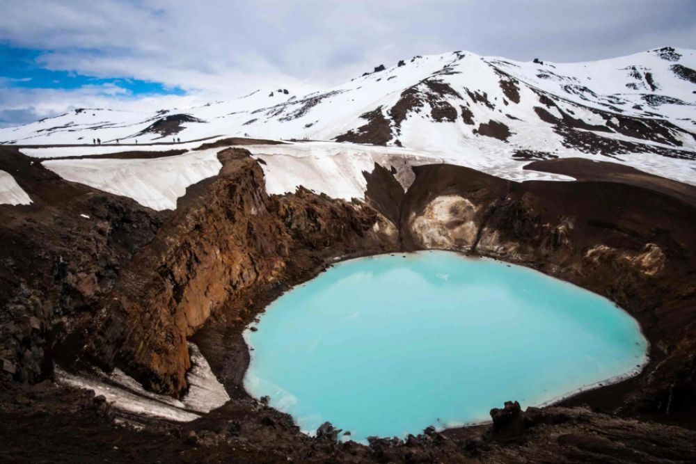
Askja: A Crater Inside a Crater
Askja is a caldera in the northeastern highlands, formed by the collapse of a magma chamber during a large eruption in 1875. That eruption sent a cloud of volcanic ash across Scandinavia and triggered a wave of emigration from Iceland to North America, as the ash poisoned pastureland across the north of the island. The caldera it left behind is roughly 50 square kilometres. Inside it, a second smaller collapse has formed Lake Öskjuvatn, which at 220 metres is one of the deepest lakes in Iceland.
Beside Öskjuvatn, a separate crater called Víti contains a geothermal lake of milky blue-white water. Víti means ‘hell’ in Icelandic. The name was given after the 1875 eruption, when the crater was still active and its association with the catastrophe that drove people from their farms was immediate. Today the water temperature sits around 20 to 30 degrees Celsius, and visitors sometimes swim in it.
The two features at Askja illustrate two different mechanisms of volcanic crater formation. Öskjuvatn formed by caldera collapse, the same process that creates large volcanic depressions worldwide. Víti is a maar, a broad shallow crater formed by a phreatomagmatic explosion, which occurs when rising magma meets groundwater or ice. The resulting steam expansion is almost instantaneous. It is the same basic mechanism that makes a glacier-capped eruption like Eyjafjallajokull so violent. The article on Iceland’s volcanoes explains the broader context of how these different eruption types shape the island.
The Institute of Earth Sciences at the University of Iceland monitors Askja and the surrounding Dyngjufjöll volcanic system continuously. The caldera last showed signs of renewed inflation in 2021, the same year that Reykjanes began its current eruptive cycle. The two events are unrelated, but they share the same underlying driver: a geologically restless island sitting on one of the most active tectonic boundaries on the planet.
How to Access the Highlands Without Damaging Them
The F-roads that cross Iceland’s interior are only open from late June to early September, depending on snowmelt and ground conditions. They are unpaved mountain tracks requiring four-wheel drive with high clearance. Attempting them in a standard vehicle is illegal and results in fines under Icelandic traffic law, as well as the near-certainty of becoming stuck in river crossings that have no bridges.
The reason for the restriction is not bureaucratic caution. The volcanic soil in the highlands is among the most fragile in the country. Where soil exists at all, it is a thin crust formed over decades or centuries, easily compacted and almost impossible to restore once disturbed. Off-road driving in these areas leaves scars that remain visible for generations. The same logic applies on foot: staying on marked paths at sites like Landmannalaugar is not a rule imposed by rangers. It is the minimum condition for the landscape to remain legible for the next person who arrives.
The highlands are also the area of Iceland where the distance between a beautiful afternoon and a serious emergency closes fastest. Weather can change within the hour. Temperatures at altitude drop below zero in any month. The responsible travel guide covers the broader framework, but the highlands ask for an additional degree of preparation that most of the coast does not. — see our guide to Iceland’s Vakinn-certified eco-tour operators for guided highland options.
March began with lava flowing toward a town on the Reykjanes Peninsula and ended here, in silence, on multicolored rock that looks like nothing the planet would produce after life had time to settle in. The highlands are not the most dramatic landscape in Iceland. They are the most honest one: the Earth as it actually is when nothing softens the surface, when there is no vegetation to reassure you that what you are standing on has been domesticated by time.
Everything the month covered, the eruptions at Reykjanes, the tectonic geometry at Silfra, the geysers of the Golden Circle, the basalt under every footstep: the highlands contain all of it, stripped back to its minimum. That is what makes them worth the journey.
Frequently Asked Questions
What makes the Icelandic Highlands so colorful?
The colors come from rhyolite, a silica-rich volcanic rock that forms in a different way from the basalt that covers most of Iceland. Iron oxides produce reds and oranges. Sulfur deposits and hydrothermal alteration create yellows and greens. The violet tones result from geothermal water moving through the rock over thousands of years. Each color is a chemical record of a specific geological process, not an accident of light.
Can you visit the Icelandic Highlands without a 4×4?
No. The F-roads that cross the highland interior are legally restricted to four-wheel drive vehicles with high ground clearance. Driving a standard vehicle on F-roads is illegal in Iceland and carries fines. The roads are also only open between late June and early September, depending on snow and ground conditions. Several highland sites, including Landmannalaugar and Askja, are also accessible via scheduled bus services that run from Reykjavik during the summer season for travelers without 4×4 vehicles.
What is the difference between Askja and Landmannalaugar?
They are distinct sites about 150 kilometres apart in the central highlands. Landmannalaugar is known for its multicolored rhyolite hills, natural hot springs, and the start of the Laugavegur hiking trail. Askja is a large volcanic caldera containing Lake Öskjuvatn and the geothermal crater Víti. Both are geologically significant, but Askja is more remote and requires a longer drive on rougher F-roads. Landmannalaugar is more accessible and better suited to visitors with limited time in the highlands.
What This Place Teaches
| The Geological LessonIceland’s highlands look the way the Earth looked before life covered its surfaces. They are not a wasteland. They are a window into deep time: the planet as it was for most of its history, before plants, before soil, before anything we would recognize as familiar. |
For Young Explorers
Pick one color you can see in a photograph of Landmannalaugar and find out what mineral produces it. Iron? Sulfur? Something else? Write one sentence explaining what that mineral tells you about the temperature and chemistry of the rock when it formed.
The Deep Time Angle
Vascular plants colonized land approximately 470 million years ago. Before that, the Earth’s surface looked close to what the Icelandic highlands look like today. The highlands are not just a geological curiosity. They are a glimpse of nearly half a billion years of planetary history, compressed into a landscape you can walk through in an afternoon.
Further Reading
The Institute of Earth Sciences at the University of Iceland publishes research on Iceland’s volcanic systems including Askja, the Dyngjufjöll massif, and the geothermal activity driving the highland landscapes. Their monitoring data is the primary scientific reference for the ongoing geological state of the central highlands.