The Oldest Rocks in Morocco Are Not Where You Think
When most travelers picture Morocco’s geology, they see the towering ridges of the Atlas Mountains rising above Marrakech. Those peaks look ancient, with their fold-and-thrust skylines and lunar valleys. But geologically speaking, the Atlas Mountains are a teenager. They began rising less than 80 million years ago.
The truly old rocks lie elsewhere. To find them, you do not climb. You drive south. Far south. Past Agadir, past Guelmim, past Tan-Tan and Tarfaya. Past Laayoune. All the way to Dakhla, where the Atlantic carves a long, calm lagoon out of the Sahara. And then you keep going, inland, on a route that takes you across one of the oldest pieces of crust still exposed on planet Earth: the West African Craton.
The rocks beneath your feet near the town of Aousserd are roughly 3 billion years old. Older than the first multicellular life. Older than any mountain range still standing today. They formed when the Earth was less than 2 billion years from its own birth, before the atmosphere held the oxygen we breathe.
This is where Morocco begins.
What Is a Craton? (One Paragraph, No Jargon)
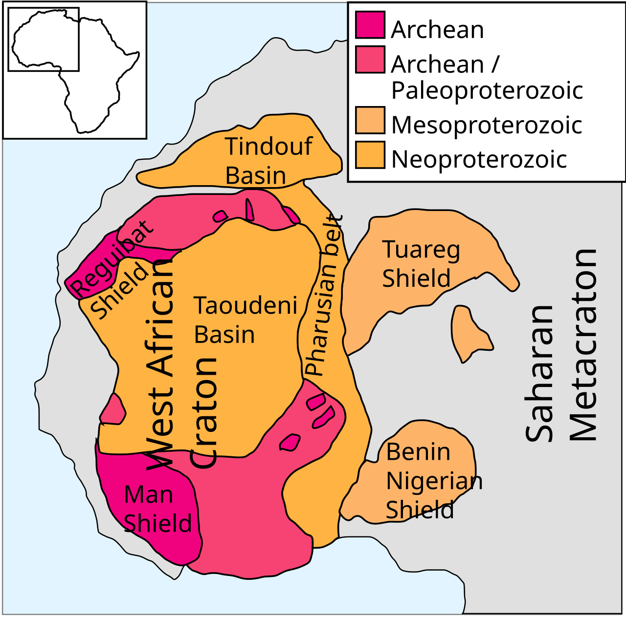
A craton is the ancient, stable heart of a continent. When you look at any continent on a map, the puzzle-piece outlines have been moving for billions of years, but they all anchor onto a central core that has been geologically still for most of Earth’s history. That core is the craton. North America has the Canadian Shield. Africa has the West African Craton, the Congo Craton, the Kalahari Craton, and a handful of smaller ones. The West African Craton extends from southern Algeria to Senegal, with its northern edge crossing into Morocco’s deep south. Where it surfaces, geologists call it the Reguibat Shield, a treasure chest of rocks from the Archean to the Paleoproterozoic.
The Reguibat Shield: A Buried Continent Under the Sand
For most of its length, the West African Craton stays hidden beneath younger sedimentary cover, including limestones, sandstones, and marls that piled on over billions of years. But in two places, the craton breaks the surface.
The first outcrop is in the deep Sahara south of Aousserd, in the Adrar Souttouf massif and the surrounding plain. The second is far to the south in Mauritania. Together, these two outcrops form what geologists call the Reguibat Shield, also known in French scientific literature as the Dorsale Reguibate.
What makes it special is what it preserves. Most of Earth’s surface has been recycled, eroded, melted, and reformed many times over its 4.5 billion year history. The Reguibat Shield has stayed geologically quiet for most of the last 2 billion years. It is like a museum where the exhibits are not behind glass but lie underfoot. You can drive across it. You can pick up its oldest rocks with your hands. (You should not, but the access is that direct.)
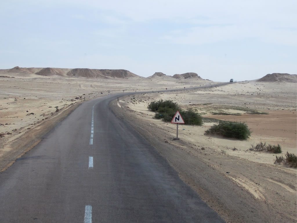
The route from Dakhla to Aousserd crosses 270 kilometers of empty desert. It is the only road in Morocco that takes you through 3 billion years of geological time in a single morning.
Aousserd: 3 Billion Years Below Your Feet
The first contact with the craton happens about 130 kilometers from the Dakhla turnoff, at a rocky crest called Dli’at An’Nsour. To untrained eyes it looks like every other Saharan hill: brown rocks, no shade, no obvious story. But for a geologist, this is the first handshake with deep time.
The rocks here are agmatites, coarse intrusive rocks that crystallized from melted magma deep in the Earth’s crust. They are dated to the Mesoarchean, roughly 3 billion years old. Around them, in the Adrar Souttouf, you can find granodiorites, micaschists, and gneisses of similar age. Some of the most ancient zircon crystals ever found in Morocco come from this region, dating back to between 2.7 and 3 billion years.
To put that into context: when these rocks first cooled from molten magma, there were no plants, no animals, no fungi, no soil as we know it. Just oceans, primitive bacteria, and a young planet learning to crust over.
You can stand on these rocks and contemplate that. The wind across the Reguibate plain has been doing the same for a very long time.
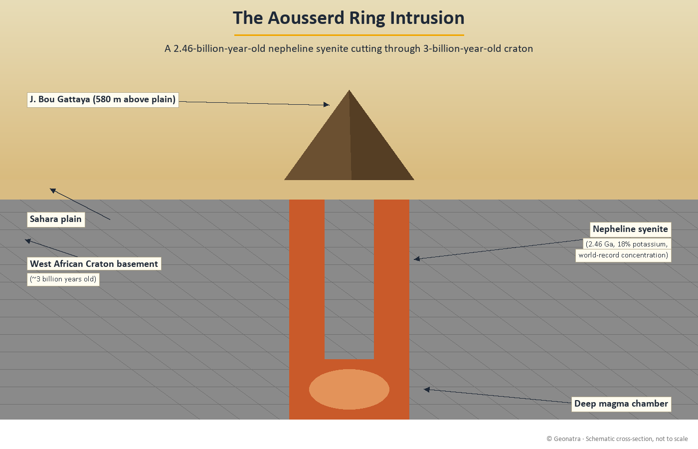
The 2.46 Billion Year Old Syenite Ring: A World Record
About 40 kilometers past Aousserd, on the flat horizon, a strange relief breaks the pancake plain: the J. Bou Gattaya, a mountain rising nearly 600 meters above the surrounding desert. From the air it looks circular. From the ground, you understand why. It is a ring intrusion, a roughly circular body of igneous rock that pushed up through the older craton from below.
What pushed up is a rock called nepheline syenite. The Aousserd ring intrusion is dated to about 2.46 billion years ago, marking a magmatic event that happened well after the craton itself was already old.
But here is the extraordinary part. The Aousserd syenites contain about 18 percent potassium, the highest concentration ever measured in syenitic rocks anywhere on Earth. They are, by some accounts, the most potassium-rich igneous rocks in the global rock record.
A Moroccan research team led by Pr. Fouzia El Heissen of Hassan II University in Casablanca has been documenting these K-rich syenites (called K-cnites locally) for years. Their work, conducted in collaboration with the University of Granada in Spain, has shown that the K-cnites could even serve as natural fertilizer, though no commercial use has emerged yet.
For now, the Aousserd syenite ring stands as a monument: a record holder hidden in a corner of the planet that almost no traveler has ever heard of.
Tichla’s Green Stone Belt: Echoes of Early Earth
Past Aousserd, the road continues toward Tichla, a small Saharan settlement near the Mauritanian border. The terrain shifts. The plain becomes rugged. You encounter dark, weathered rocks emerging from the sand: metabasalts, metagabbros, and serpentinites, all metamorphosed equivalents of ancient ocean floor.
This is a green stone belt, one of the most diagnostic rock formations of early Earth. Green stone belts are the relics of early oceanic crust that was thrust onto the cratons before plate tectonics behaved the way it does today. They preserve a record of what the Earth was like when the planet’s interior was hotter, the mantle convected faster, and the boundary between continents and oceans had not yet fully crystallized.
The Tichla green stones, like the Reguibate granites, date from the late Archean and early Paleoproterozoic. They give us a window into the chemistry of the very first oceans. The scientists who study them are essentially reading the diary of a young planet.
When Africa First Built Mountains: The Eburnean Event
Around 2 billion years ago, a tectonic episode called the Eburnean orogeny swept across what is today West Africa. It was the first major mountain-building event in the region. We do not have eyewitness reports, obviously, but we have its rock signatures: deformed and metamorphosed granites, intensely folded gneisses, and a set of unusual carbonate rocks at a place called Guelb Zemmour.
The Guelb Zemmour carbonates puzzle geologists. They are sedimentary rocks (carbonate platforms) that have been chemically altered by hot, carbon-rich fluids coming from the mantle. Their isotopic signatures are unlike anything you would expect from a typical limestone deposit.
A nearby granite, called the Drâa granite and dated at around 525 million years (much younger), nonetheless carries an inherited geochemical signature dating back to roughly 1.85 billion years, the same age as the Guelb Zemmour carbonates. This tells geologists that the deep roots of the West African Craton remained chemically connected across more than a billion years of Earth history.
The Eburnean event left a deep imprint that newer magmas continued to tap into long afterward.
How to Visit: A Geotourist’s Guide to Morocco’s Deep Time Trail
A few honest words on logistics, because this part of Morocco is not Marrakech.
Where it is. The Reguibate craton crops out in the deep south of Morocco, in the provinces around Aousserd and Tichla. From Casablanca, you fly to Dakhla, about a two-hour flight. From Dakhla, you drive 270 kilometers south to Aousserd, then another 140 kilometers to Tichla. The road is paved most of the way, with some piste sections at the end.
Permits. This region is administered as a sensitive security zone. To visit, you need a written authorization from the Direction du Développement Minier at the Ministry of Energy and Mines in Rabat. Contact the Division du Patrimoine before you travel. The process takes time, so plan ahead.
Duration. Six to eight days from Agadir round trip, depending on whether you cut the Smara loop or extend toward Tichla. A return flight from Dakhla to Casablanca significantly shortens the journey.
Maps. The 1:50,000 geological maps of Awsard (2002, by Rjimati and colleagues) and Tichla (in preparation) are essential. The Tilamsoun and Ayoun Draa sheets cover the approach roads. Copies can be requested from the Service Géologique du Maroc in Rabat.
What to bring. Plenty of water. Sun protection. A handheld GPS. Comfortable hiking boots. A geological hammer is unnecessary unless you are conducting research. Take photos, leave the rocks where they are.
Best season. Late autumn through early spring. Summer is unmanageable. Temperatures near Aousserd routinely exceed 45 degrees Celsius.
Morocco’s Tectonic Trilogy: Why the Craton Matters
The West African Craton is the foundation. Everything that came after in Morocco’s geological history was layered onto this ancient core.
In future chapters of this series, we will follow that history forward. The Anti-Atlas formed when the Pan-African orogeny welded younger terranes onto the craton, between 800 and 550 million years ago. The Mesetas record a later episode of mountain building during the Variscan orogeny, roughly 350 to 250 million years ago. The Atlas Mountains themselves are the product of relatively recent compression, less than 80 million years old. And the Rif marks where Africa is colliding with Europe right now.
But there is a bigger context too. Geonatra’s deep time exploration started in Iceland, where the Earth’s crust is actively pulling apart along the Mid-Atlantic Ridge. It continued in Japan, where the Pacific Plate dives into a subduction zone, building volcanoes and earthquakes. Morocco completes a tectonic trilogy: rifting, subduction, and now a quiet ancient continent that records what happened before either of those processes existed in their modern form.
Each destination tells a different chapter of the same story: how a planet stays alive geologically over 4.5 billion years.
Frequently Asked Questions
Where are the oldest rocks in Morocco?
The oldest rocks in Morocco are found in the deep south, near the town of Aousserd in the Sahara. They are part of the Reguibat Shield, an exposure of the West African Craton, and date from the Mesoarchean, approximately 3 billion years old.
Can tourists visit Aousserd?
Yes, but the area is administered as a security zone. Visitors need a written authorization from the Direction du Développement Minier at the Ministry of Energy and Mines in Rabat. Travel is typically by road from Dakhla, with the journey taking one full day each way.
What is the West African Craton?
The West African Craton is one of the oldest tectonic blocks on Earth. It forms the geological foundation of much of West Africa, from southern Algeria to Senegal. In Morocco, it surfaces as the Reguibat Shield, with rocks including granites, gneisses, and metamorphic units up to 3 billion years old.
What is unique about the Aousserd syenite?
The Aousserd ring intrusion contains nepheline syenites with about 18 percent potassium, the highest concentration ever recorded in syenitic rocks worldwide. These ultra-potassic rocks crystallized roughly 2.46 billion years ago.
Is it safe to travel to the Moroccan Sahara?
The region is safe when traveled with proper authorization and appropriate preparation. Distances between settlements are long, water and fuel must be carried, and summer temperatures are extreme. Always travel in groups and inform local authorities of your route.