
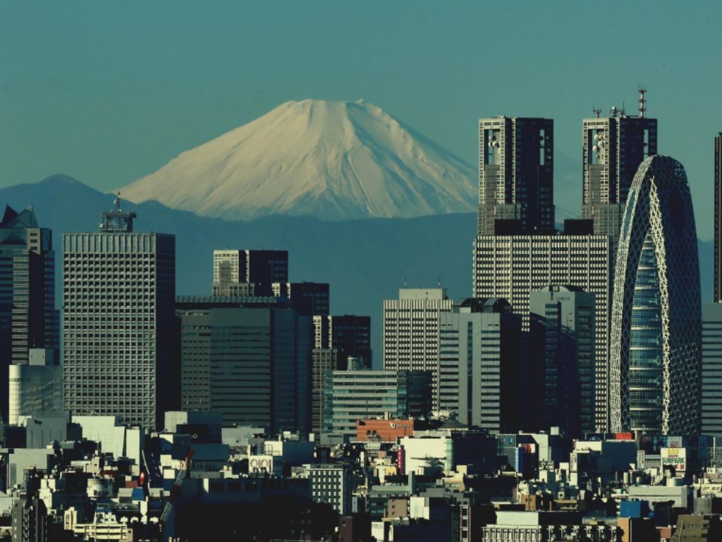
At three in the morning, Tokyo trembles. The glass on the bedside table shifts a millimetre and stills. A train pauses for thirty seconds at Shibuya. A wooden beam in an old Asakusa house complains softly, then forgets. By the time the city is fully awake, the small earthquake has already been logged, mapped and forwarded to a screen at the Japan Meteorological Agency. Nobody woke up.
The movement came from somewhere. Sixty kilometres beneath the bedside table, a slab of cold ocean floor is sliding under the country. It has been doing so for tens of millions of years. It will keep doing so long after Tokyo is forgotten. The volcanoes you can see from the bullet train, the hot water that fills the bath in your ryokan, the obsidian arrowheads in the Ueno museum. All the same conversation, told in different voices.
Japan Volcanoes Explained: The Short Version
Japan volcanoes explained in fifty words: four tectonic plates converge beneath the archipelago. The Pacific Plate dives under Japan, sinks into the hot mantle, and releases water that melts the rock above. That melt rises as magma. The result is roughly one hundred and ten active volcanoes, from Hokkaido in the north to Kyushu in the south.
Four Plates, One Archipelago
Most countries sit on one plate. Japan sits on a junction.
Four tectonic plates meet under the archipelago: the Pacific Plate from the east, the Philippine Sea Plate from the south, the Eurasian Plate to the west, and the North American Plate (or its smaller Okhotsk extension) to the north. They converge at different angles, at different speeds, and they have been doing so for at least fifteen million years. The country we see today is the surface expression of that quiet, patient grinding.
Iceland, the subject of our first season, sits on a different geometry. Two plates pull apart there. Magma rises into the gap and freezes into new ground. Iceland grows by spreading. Japan does the opposite. Two plates push together, one slides under the other, and the surface buckles upward. Japan grows by colliding. The mechanism is reversed, but the result is the same in spirit: a young country, restless and visible.
This is why a basic map of Japan looks the way it does. The long curved spine of Honshu mirrors the curve of the trench off its east coast. The trench is where the Pacific Plate begins its descent. Behind every trench like that, a few hundred kilometres further inland, an arc of volcanoes appears. Geologists call them volcanic arcs. The world has dozens. Japan is one of the clearest.
Look at a satellite image and the pattern is almost too neat. From the Kuril Islands in the far north, down through Hokkaido, Honshu, the Izu chain and the Ryukyus to the south, a string of volcanic peaks traces the same gentle bow. Each peak sits the same distance from the trench. Each was built by the same plumbing. The country is not a random scatter of mountains. It is a sentence written in fire, with a clear grammar. That grammar is what the rest of this guide will help you read.
What Subduction Actually Does
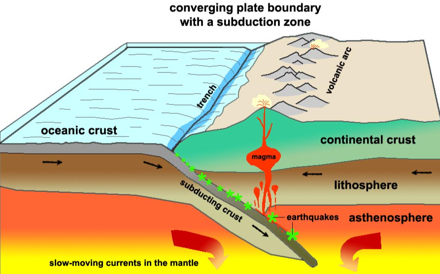
The word subduction sounds technical. The mechanism is not.
Take a slab of cold, wet ocean floor and push it slowly under a hotter continent. As it descends, the slab is squeezed, fractured and warmed. Around eighty to one hundred kilometres down, the temperature is high enough to start cooking the water out of the slab’s wet minerals. That water rises into the rock above.
Water is the unsung protagonist of every subduction zone. Hot rock alone does not melt easily. Hot rock with a little water in it melts at a much lower temperature. So the water released from the descending slab acts like a seasoning that triggers melting in the wedge of mantle just above. A column of magma begins to grow.That column does not rise straight to the surface. It collects, mixes, evolves. Some of it cools at depth and forms granite, the slow-cooled cousin of lava. Some of it makes it up the last twenty or thirty kilometres of crust, finds a weakness, and erupts. When it does, it builds the kind of steep, layered, photogenic cone we associate with Japan.
The same machinery also produces three other things you will recognise. It produces deep ocean trenches, like the Japan Trench off Tohoku, where the Pacific Plate first begins its descent. It produces earthquakes at every level of the slab as it grinds downward, from shallow shocks at the trench to deep events four hundred kilometres beneath the surface. And it produces hot springs, because the same underground heat that feeds volcanoes also warms groundwater enough to surface as steam.
We will return to that water later. It is the link to the Japan’s Hot Springs Science piece coming later this month. So the volcanoes, the trenches, the earthquakes and the onsen are not four separate Japanese phenomena. They are four faces of the same descending slab.
Japan’s Volcanic Zones
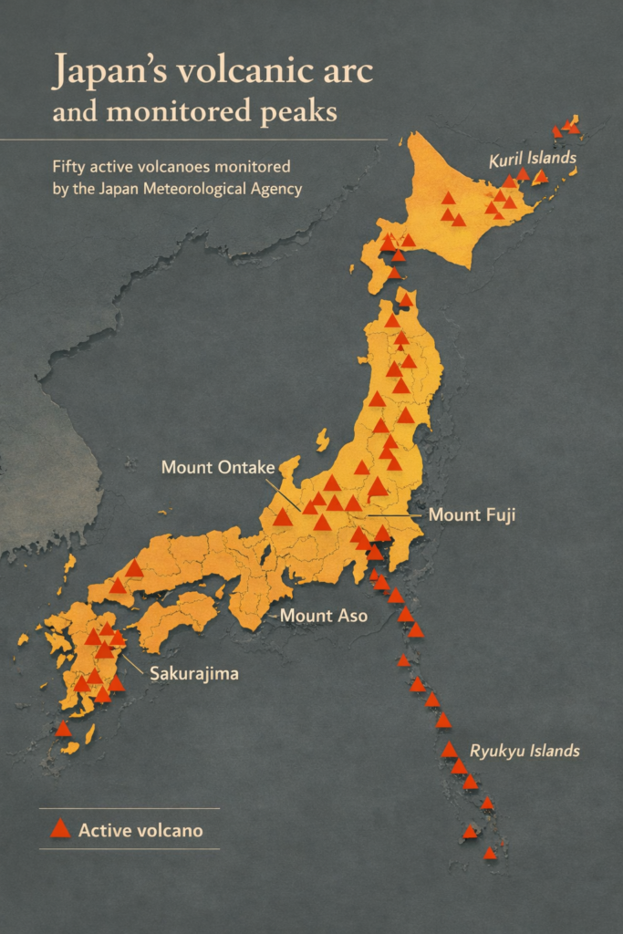
Japan’s active volcanoes are conventionally grouped into a handful of zones strung along the arc.
In the far north, the East Hokkaido and Daisetsu zones include peaks like Tokachi, Meakan and Tarumae. They sit above the Pacific Plate’s deepest descent, and their eruptions tend to be ash-rich and explosive. Move south and you reach the Northeast Honshu zone, with Mount Iwate and Bandai. Bandai erupted catastrophically in 1888 and reshaped its own profile in a single afternoon.
The Central Honshu zone is the one most travellers pass through. It includes Asama, Yatsugatake and the cluster around the Hakone caldera. Mount Fuji belongs to a slightly separate volcanic front where the Philippine Sea Plate is the principal driver. Fuji is the textbook stratovolcano of subduction: tall, symmetrical, layered with andesite, gentle from a distance and lethal up close. The grey of its slopes is the colour of subduction itself, the typical chemistry of an arc magma that has cooled into andesite rather than the darker basalt of an ocean ridge.
Further south, the Kyushu zone gathers some of the most violently active centres in the country. Aso shelters the largest inhabited caldera on Earth. Sakurajima erupts almost daily and dusts Kagoshima in fine ash. The Ryukyu chain, trailing off to Okinawa, sits where the Philippine Sea Plate slides beneath the Eurasian Plate at a different angle, and its volcanoes are smaller and sparser.Seen from above, the chain is uncannily continuous. From Kamchatka in the north, down through Kuril, Hokkaido, Honshu, the Izu-Bonin chain and the Marianas in the south, the same arc keeps going. Japan is the most populated stretch of one of the longest volcanic arcs on the planet. That arc is part of a larger pattern that loops around almost the entire Pacific basin, a pattern travellers have a nickname for and which we wrote about in detail when we explored Japan’s place inside the Ring of Fire.
The point worth keeping is this. The volcanoes of Japan are not scattered, and they are not random. They are the regular, predictable signature of a slab descending below your feet.
When the Earth Speaks
A country built on a subducting plate cannot be a quiet country.
In 1923, the Great Kanto earthquake destroyed much of Tokyo and Yokohama. The shaking lasted nearly five minutes. The fires that followed lasted three days. More than one hundred thousand people died. The cause was a sudden slip on the boundary between the Philippine Sea Plate and the slab above it, just south of the city.
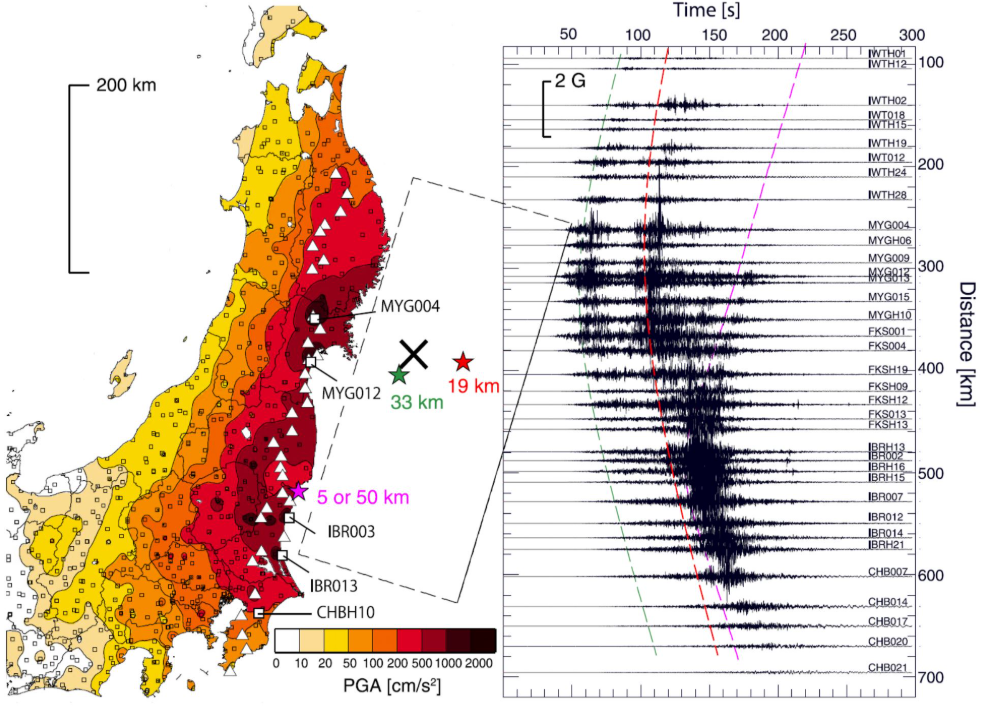
In March 2011, off the coast of Tohoku, an even larger event occurred. A section of the Pacific Plate roughly four hundred and fifty kilometres long lurched eastward by tens of metres in a few minutes. The seafloor lifted. A tsunami crossed the coast. The earthquake itself was a magnitude 9.0, the largest ever recorded in Japan and the fourth largest worldwide since modern instruments began listening.Both events were tragedies, and there is nothing in the geology that softens that. But both events were also exactly what one would expect a subduction zone to do, sooner or later. The Japan Meteorological Agency catalogues this conversation in real time. Their public network records, on average, around fifteen hundred earthquakes per month across the archipelago. Most are too small to feel. A few each year are noticed in passing, the way Tokyo noticed the tremor in our opening scene. Once or twice a generation, the slab releases a stored century of stress all at once.
Reading the Tohoku event as catastrophe is correct. Reading it only as catastrophe is incomplete. The same plate motion that brought the shaking also built the very land that the country now stands on. The cliffs of the Sanriku coast, the rivers that feed Sendai, the rice plains around them: all of these are deposits, uplifts and deformations of an arc still under construction. To live in Japan is to live on a sentence that is still being written. For the human side of that idea, see the tectonic truth behind Japan’s earthquakes.
Reading the Landscape
Once you know the machinery, the rocks of Japan stop being decorative and start being readable.
The dominant volcanic rock of the archipelago is andesite. It is grey, fine-grained, often speckled with small white or dark crystals. It is the typical product of an arc magma that has lost some of its iron and gained some silica on its way up. Most of Mount Fuji is andesite. Most of Hakone is andesite. The grey of those slopes is not aesthetic. It is chemistry.
Basalt, the darker, denser rock you find on Iceland’s coasts, also exists in Japan, especially on volcanic islands at the edge of the arc and on flows that erupted very quickly. It tells you the magma came up fast and was not given time to evolve.Then there is obsidian, the volcanic glass. When andesitic or rhyolitic magma cools too fast to crystallise, it freezes into a smooth black glass that flakes into edges sharper than steel. Japan’s prehistoric Jomon people knew this. They quarried obsidian from sites like Kozushima and Wada Pass, traded it across the islands, and turned it into arrowheads, scrapers and blades. The obsidian was geological. The trade routes were not.
If you walk past a temple wall built of grey blocks in Kyoto, look closely. You may be looking at andesite quarried from a nearby flow. If you stand on the black sand of a beach in Kagoshima, you are walking on the broken-down basalt of a recent eruption. None of this requires special training to see, only a habit of asking what the rock is. We laid out a fuller field guide in our piece on how to read the rocks of a subduction zone.
Traveling with children? We put together a companion piece on teaching kids to read Japan’s volcanic landscape — the same rocks, explained for younger eyes.
Japan’s Geological Future
The Pacific Plate is currently moving westward at roughly eight centimetres per year. That is about the speed at which a fingernail grows. Continued over ten million years, it adds up to eight hundred kilometres of new subduction. Continued over a hundred million years, it adds up to a different geography altogether.
If the present pattern holds, the Japanese arc will keep building. New volcanoes will emerge along the front. Existing ones will exhaust their plumbing and fall silent, slowly weathering down into hills with vague, half-erased shapes. The Sea of Japan, which opened behind the arc roughly fifteen million years ago, may continue to widen, or it may begin to close again under different stresses. Geologists do not predict tens of millions of years with any certainty. They read the patterns and watch.
What is more certain is that the country itself, in its current arrangement of islands and ranges, is a snapshot of a particular moment. Looked at from a different timescale, the islands you visit are mid-sentence. They drift, they tilt, they grow taller in some places and subside in others. The Mount Fuji of three million years from now, if it exists, will not be the cone in your photograph. That long view is not a downer. It is the opposite. It is the reason a single morning spent on a Japanese coast can feel weighted with meaning that a thousand identical mornings elsewhere do not carry. A fuller view of that timescale is laid out in our look at when these islands actually formed.
Frequently Asked Questions
How many active volcanoes does Japan have?
The Japan Meteorological Agency currently lists around one hundred and eleven active volcanoes, with a smaller subset of about fifty under continuous observation. Active here means a volcano that has erupted in the last ten thousand years or shows signs of unrest. The number rises slightly every few decades as monitoring improves.
Is Mount Fuji likely to erupt soon?
Fuji’s last eruption was the Hoei event of 1707. By the standards of an active stratovolcano, three hundred years of silence is not unusual, and there is no current sign of imminent unrest. Geologists watch it carefully, but the probability of an eruption in any given year remains low.
Why does Japan have so many onsen?
Hot springs are the surface expression of the same heat that drives the volcanoes. Groundwater meets warm rock, rises, and emerges as steam or warm water at thousands of points across the country. The science is laid out in detail in our Japan’s Hot Springs Science piece.
Why is Japan different from Iceland?
Iceland sits where two plates pull apart, so its volcanism is quiet basalt and its land grows by spreading. Japan sits where plates push together, so its volcanism is explosive andesite and its land grows by colliding. Same family, opposite mechanism.
About the Author
Daniel writes for Geonatra from the field, reading landscapes the way others read libraries. His Japan notebooks were filled walking the foothills of Honshu, the granite coastlines of Yakushima and the volcanic ridges of Kyushu, with one quiet question in mind: how a country this young can carry such old stones.